Abiquiu Formation
The Abiquiu Formation is a geologic formation in northern New Mexico. Radiometric dating constrains its age to between 18 million and 27 million years, corresponding to the late Oligocene to Miocene epochs.[1]
| Abiquiu Formation Stratigraphic range: Oligocene to Miocene | |
|---|---|
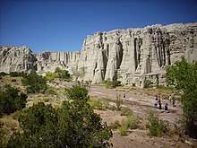 Abiquiu Formation at Plaza Blanca, north of Abiquiu, New Mexico | |
| Type | Formation |
| Unit of | Santa Fe Group |
| Sub-units | Pedernal Chert |
| Underlies | Tesuque Formation |
| Overlies | El Rito Formation |
| Thickness | 400 m (1,300 ft) |
| Lithology | |
| Primary | Tuff |
| Other | Sandstone, conglomerate |
| Location | |
| Coordinates | 36.240°N 106.298°W |
| Region | New Mexico |
| Country | United States |
| Type section | |
| Named for | Abiquiu, New Mexico |
| Named by | H.T.U. Smith |
| Year defined | 1938 |
 Abiquiu Formation (the United States)  Abiquiu Formation (New Mexico) | |
The formation is composed mostly of volcanic debris from the Latir volcanic field, and records the early stages of the opening of the Rio Grande rift in northern New Mexico.[2][3]
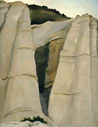
Georgia O'Keeffe drew inspiration from her study of the formation at Plaza Blanca.[4]
Description
The Abiquiu Formation consists of light-gray to yellowish-gray, locally crossbedded, thin to thick beds of tuffaceous sandstone, pebbly sandstone, and siltstone. There are also a few gravel beds and lenses of mudstone. The clasts are mostly of volcanic rock, including Amalia Tuff and trachyandesite and trachydacite possibly also from the Latir volcanic field. The formation is exposed in a broad belt from the southwest flank of the Tusas Mountains to the Jarosa area in the northwest Jemez Mountains.[5][6] The formation reaches a maximum thickness in excess of 400 meters (1,300 feet) near Cañones. The age of the formation is approximately bracketed by a lava flow near its top dated to 18.9 Ma and a 25 Ma flow near its base.[1]
Both the lower contact of the formation with the Ritito Conglomerate and the upper contact with the Chama-El Rito Member of the Tesuque Formation are gradational. The transition to the Ritito Conglomerate is characterized by thick chert beds, informally designated the Pedernal chert for outcrops around Cerro Pedernal (36.163°N 106.512°W).[1]
Individual beds in the formation thicken across the Canones fault zone, which separates the Colorado Plateau from the Rio Grande rift. This indicates that the formation was deposited after rifting began within the Rio Grande rift.[1]
The formation correlates with the Cordito Member of the Los Pinos Formation[6]
History of investigation
The Abiquiu Tuff was first named by H.T.U. Smith in 1938 for exposures near the town of Abiquiu, New Mexico. Smith designated only a type area[7] and no type locality has been defined.[8] Church and Hack recognized almost at once that the unit consisted of a lower conglomeratic member and an upper tuff member separated by a chert horizon (the Pedernal chert member).[2] Woodward and Timmer first referred to the unit as the Abiquiu Formation in 1979.[9] In 2009, Maldonado and Kelley correlated the lower conglomerate beds with the Ritito Conglomerate and removed them from the formation, retaining Pedernal Chert as an informal name for the chert beds of the transition between the Ritito Conglomerate and Abiquiu Formation.[3]
Cultural importance
Georgia O'Keeffe painted her landscape "From the White Place" in 1940 based on her study of the Abiquiu Formation at Plaza Blanca, and her studio at Abiquiu commanded a view of the Plaza Blanca outcrops to the north.[4]
Footnotes
- Maldonado and Kelley 2009, p.6
- Church and Hack 1939
- Maldonado and Kelley 2009
- http://www.georgiaokeeffe.org/from-the-white-place/
- Vazzana and Ingersoll 1981, p.2467
- Maldonado and Kelley 2009, p.5
- Smith 1938
- GEOLEX: Abiquiu
- Woodward and Timmer 1979
References
- Church, Fermor S.; Hack, John T. (August 1939). "An Exhumed Erosion Surface in the Jemez Mountains, New Mexico". The Journal of Geology. 47 (6): 613–629. doi:10.1086/624816.
- Maldonado, Florian; Kelley, Shari A. (February 2009). "Revisions to the stratigraphic nomenclature of the Abiquiu Formation, Abiquiu and contiguous areas, north-central New Mexico" (PDF). New Mexico Geology. 31 (1): 3–8. Retrieved 12 May 2020.
- Smith, Harold T. U. (October 1938). "Tertiary Geology of the Abiquiu Quadrangle, New Mexico". The Journal of Geology. 46 (7): 933–965. doi:10.1086/624710.
- Vazzana, M. E.; Ingersoll, R. V. (December 1981). "Stratigraphy, Sedimentology, Petrology, and Basin Evolution of the Abiquiu Formation (Oligo-Miocene), North-Central New Mexico". GSA Bulletin. 92 (12_Part_II): 2401–2483. doi:10.1130/GSAB-P2-92-2401.
- Woodward, L.A.; Timmer, R.S. (1979). "Geology of the Jarosa quadrangle, New Mexico". New Mexico Bureau of Mines and Mineral Resources Geologic Map. 47. Retrieved 10 August 2020.