Edo Five Routes
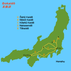
The Five Routes (五街道, Gokaidō), sometimes translated as "Five Highways", were the five centrally administered routes, or kaidō, that connected the capital of Japan at Edo (now Tokyo) with the outer provinces during the Edo period (1603–1868).[1] The most important of the routes was the Tōkaidō, which linked Edo and Kyoto. Tokugawa Ieyasu started the construction of these five routes to increase his control over the country in 1601, but it was Tokugawa Ietsuna, the 4th shōgun of the Tokugawa shogunate and Ieyasu's great-grandson, who declared them as major routes. Post stations were set up along the route for travelers to rest and buy supplies.[1] The routes thrived due to the policy of sankin-kōtai, that required the daimyōs (regional rulers) to travel in alternate years along the routes to Edo.[1]

History
The various roads that make up the Five Routes existed in some form before becoming an official set of routes. Tokugawa Ieyasu began work on the routes shortly after becoming shōgun in 1600. The official creation of the Five Routes began with the shogunate taking government control of the post stations along the existing routes.[2] Before this intervention, the post stations provided places for travelers to rest and ran a courier system. After the official takeover, the Shogunate required that these stations give preferential treatment to those on official business or be forced to cease activity. In the 1640s, shōgun Tokugawa Iemitsu closed down all but the necessary stations, which would be the last major change during the Edo period.[2]
Along with the Post Stations, the government created a system of Check Stations along the Five Routes. Unlike the Post Stations, which provided for travelers, the Check Stations served a regulatory purpose, controlling the movement of people and goods. Some of the uses of these stations were preventing the trafficking of firearms, ensuring that the various rules and policies surrounding the sankin-kōtai were followed, and checking the passports of travelling commoners. Fifty-three Check Stations were created in the 17th century.[3] (This is not to be confused with the 53 Stations of the Tōkaidō, which refers to the Post Stations on the Tōkaidō.)
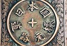
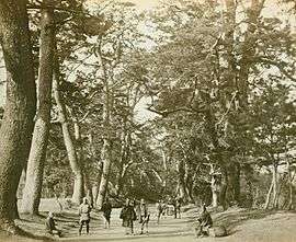
The shogunate also coordinated general improvements to the roads of the Five Routes. The roads were flattened and widened, with steeper sections paved with rough stone. Trees were planted alongside the road, and drainage ditches were dug in many places. Markers were put up to indicate distance at each ri, which was defined at the time as 3.93 km (2.44 mi) from the starting point at Nihonbashi. While the Five Routes crossed many waterways, few bridges were built. Instead, ferry boats were instituted.[3]
Five Routes


All five routes started at Nihonbashi in Edo. From that point, each road linked the capital with other parts of the country.
- Tōkaidō
- The Tōkaidō had 53 stations, connecting with Kyoto.[4] Once it reached Kusatsu-juku, it shared its route with the Nakasendō.
- Nakasendō
- The Nakasendō (also often called the Kisokaidō) had 69 stations and ran through the center of Honshū, connecting with Kyoto. The Nakasendō's Shimosuwa-shuku served as the end point for the Kōshū Kaidō. Also, the Nakasendō merged with the Tōkaidō at Kusatsu-juku.[5]
- Kōshū Kaidō
- The Kōshū Kaidō had 44 stations, connecting with Kai Province (Yamanashi Prefecture), before ending at the Nakasendō's Shimosuwa-shuku.[6]
- Ōshū Kaidō
- The Ōshū Kaidō had 27 stations, connecting with Mutsu Province (Fukushima Prefecture). There were subroutes that connected to other places of northern Japan, too.[7]
- Nikkō Kaidō
- The Nikkō Kaidō had 21 stations, connecting with Nikkō Tōshō-gū in modern-day Tochigi Prefecture.[8]
Other official routes
As part of the Five Routes network, eight minor routes were also created by the shogunate:[3]
- Aizu Nishi Kaidō
- Honzaka Dōri
- Mibudō
- Minoji
- Mito Kaidō
- Nikkō Onari Kaidō
- Nikkō Reiheishi Kaidō
- Sayaji
- Yamazaki Dōri
Unofficial routes
In addition to the five routes, there were minor routes that were unofficial branches of or alternates to the main routes, or infrequently used routes. Some of the routes were referred to as hime kaidō, as they were alternate paths for main trade routes, but none were officially called that.
|
|
|
See also
References
| Wikimedia Commons has media related to Five Routes of the Edo period. |
- "Gokaidō". Encyclopedia of Japan. Tokyo: Shogakukan. 2012. OCLC 56431036. Archived from the original on 2007-08-25. Retrieved 2012-11-10.
- Vaporis, Constantine (1986). "Post Station and Assisting Villages. Corvέe Labor and Peasant Contention". Monumenta Nipponica.
- Vaporis, Constantine (2012). "Linking the Realm: The Gokaidô Highway Network in Early Modern Japan (1603–1868)". Highways, Byways, and Road Systems in the Pre-Modern World.
- Forbes, Andrew; Henley, David (2014). Utagawa Hiroshige's 53 Stations of the Tokaido. Chiang Mai: Cognoscenti Books. B00LM4APAI
- WebJapan Atlas: Nakasendo. Accessed August 2, 2007.
- Yumekaidō: Kōshū Kaidō Map (in Japanese) (Translate to English: Google, Bing). Accessed September 4, 2007.
- Yumekaidō: Ōshū Kaidō Map (in Japanese) (Translate to English: Google, Bing). Accessed September 4, 2007.
- Nikkōdō (in Japanese) (Translate to English: Google, Bing) "Archived copy". Archived from the original on December 12, 2007. Retrieved 2007-12-08.CS1 maint: archived copy as title (link) CS1 maint: BOT: original-url status unknown (link). Accessed August 15, 2007.
- Nagasaki Kaidō Archived 2008-04-08 at the Wayback Machine. (in Japanese) Nagasaki Prefecture. Accessed March 12, 2008.