Eba, South Australia
Eba is a locality in the Murray Mallee region of South Australia, between the Mount Lofty Ranges and the Murray River. It is on the Thiele Highway and was on the Morgan railway line, 10 kilometres (6.2 mi) southwest of Morgan near the northwest bend of the Murray River.
| Eba South Australia | |||||||||||||||
|---|---|---|---|---|---|---|---|---|---|---|---|---|---|---|---|
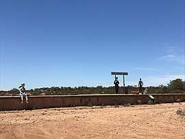
 Railway siding with novelty "passengers", December 2018 | |||||||||||||||
 Eba | |||||||||||||||
| Coordinates | 34.06°S 139.58°E | ||||||||||||||
| Population | 611 (shared with other localities in the 'State Suburb of Morgan') (2011 census)[1] | ||||||||||||||
| Established | 27 March 2003[2] | ||||||||||||||
| Postcode(s) | 5320 | ||||||||||||||
| Elevation | 38 m (125 ft) | ||||||||||||||
| Location | 10 km (6 mi) SW of Morgan | ||||||||||||||
| LGA(s) | Mid Murray Council | ||||||||||||||
| State electorate(s) | Chaffey[3] | ||||||||||||||
| Federal Division(s) | Barker[4] | ||||||||||||||
| |||||||||||||||
History
The locality of Eba occupies the western half of the Hundred of Eba which was declared in 1860 and named after a friend of the governor. The railway siding was named for the hundred when the railway was built in 1878. The current boundaries were created in 2003 for the long-established name.[5] Little remains of the village today, however it once had a post office, school,[6] blacksmith, grocery business and sawmill sending firewood to Adelaide[7] and a cricket team.[8]
References
- Australian Bureau of Statistics (31 October 2012). "Morgan (State Suburb) (sic)". 2011 Census QuickStats. Retrieved 29 June 2016.

- WEATHERILL, J. (27 March 2003). "GEOGRAPHICAL NAMES ACT 1991 Notice to Assign Names and Boundaries to Places (in the Mid Murray Council)" (PDF). the South Australian Government Gazette. South Australian Government. p. 1184. Retrieved 2 April 2018.
- "Electoral district of Chaffey". Electoral Commission SA. Retrieved 27 March 2018.
- "Electoral division of Barker" (PDF). Australian Electoral Commission. Retrieved 27 March 2018.
- "Placename Details: Eba". Property Location Browser. Government of South Australia. 11 August 2008. SA0032306. Retrieved 26 April 2016.
- "EBA". The Chronicle. 48 (2, 468). South Australia. 9 December 1905. p. 13. Retrieved 26 April 2016 – via National Library of Australia.
- "EBA". Kapunda Herald. XLIV (3, 464). South Australia. 11 September 1908. p. 5. Retrieved 26 April 2016 – via National Library of Australia.
- "EBA". The Chronicle. 46 (2, 389). South Australia. 4 June 1904. p. 13. Retrieved 26 April 2016 – via National Library of Australia.
External links
![]()