East Redonda Island
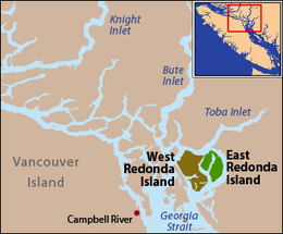
East Redonda Island is a coastal island in British Columbia, Canada, part of the Discovery Islands archipelago. It lies just to the north of Desolation Sound Marine Park, which is located off the north end of the Malaspina Peninsula at the mouth of Toba Inlet within Electoral Area C of the Strathcona Regional District.
 East and West Redonda Islands are located just north of Desolation Sound, near the mouth of Toba Inlet. | |
| Geography | |
|---|---|
| Location | British Columbia |
| Coordinates | 50°14′N 124°43′W |
| Highest elevation | 1,591 m (5,220 ft) |
| Highest point | Mount Addenbroke |
| Administration | |
This island is separated from the larger West Redonda Island by Waddington Channel. The eastern side of the island is separated from the mainland by the deep Homfray Channel. Deeply incising this island from Waddington Channel is Pendrell Sound, which runs toward the northeast. At the northern end of the island is Pryce Channel.
The eastern half of the island is home to the "East Redonda Island Ecological Reserve", a preserve established for forestry research and forest growth. It is 6,212 ha (15,350 acres).
The highest point on East Redonda Island is Mount Addenbroke at 1,591 metres (5,220 feet). (50° 14' N; 124° 41' W)
Both Redonda Islands were sighted in 1792 by the Spanish explorers Galiano and Valdés and given the name Isla Redonda, meaning "round".[1]
References
- "BCGNIS - Redonda Islands". British Columbia Geographic Names Information System. Retrieved 2008-04-01.