East 105th Street station
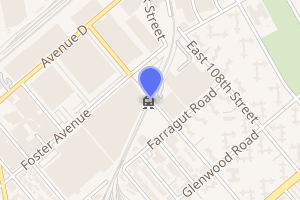
East 105th Street is a grade-level station on the BMT Canarsie Line of the New York City Subway. Located near East 105th Street between Foster Avenue and Farragut Road in Canarsie, Brooklyn,[3] it is served by the L train at all times.[4]
East 105 Street | |||||||
|---|---|---|---|---|---|---|---|
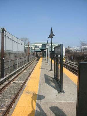
 Platform view; the station house at East 105th Street is in the background | |||||||
| Station statistics | |||||||
| Address | East 105th Street & Farragut Road Brooklyn, NY 11236 | ||||||
| Borough | Brooklyn | ||||||
| Locale | Canarsie | ||||||
| Coordinates | 40.651308°N 73.899021°W | ||||||
| Division | B (BMT) | ||||||
| Line | BMT Canarsie Line | ||||||
| Services | L | ||||||
| Structure | At-grade | ||||||
| Platforms | 1 island platform | ||||||
| Tracks | 3 (1 not for passenger service) | ||||||
| Other information | |||||||
| Opened | July 28, 1906 | ||||||
| Station code | 137[1] | ||||||
| Opposite-direction transfer available | Yes | ||||||
| Traffic | |||||||
| Passengers (2019) | 1,001,343[2] | ||||||
| Rank | 361 out of 424[2] | ||||||
| Station succession | |||||||
| Next north | New Lots Avenue: L | ||||||
| Next south | Canarsie – Rockaway Parkway: L | ||||||
| |||||||
| |||||||
| |||||||
History
This opened on July 28, 1906 as a replacement for a former station along a steam dummy line known as the Brooklyn and Rockaway Beach Railroad.
The station was rebuilt twice: in the 1970s and in 2005. The latter renovation cost $9.66 million.[5]
Station layout
| M | Mezzanine | Fare control, station agent |
| G Platform level | ||
| Yard lead | No passenger service | |
| Westbound | ← | |
| Island platform | ||
| Eastbound | | |
| Street level | Exit/entrance | |
This grade-level station has three tracks and a narrow island platform. The platform, which only has one single-sided bench, serves the middle track (Manhattan-bound) and northern one (Rockaway Parkway-bound). The southern-most track is a stub-end track that leads to the Canarsie Yard.[6]
The only grade crossing of the subway system was located at where East 105th Street crossed the Canarsie Line.[7] It was eliminated in the 1970s and is located at the site of the current station house. The crossing was closed on August 5, 1973.[8][9][10] The grade crossing elimination was part of the construction of the Flatlands Industrial Park.[11]
The MTA still lists the station being at Turnbull Avenue, a dirt road which once ran along the tracks but no longer exists.[12] A part of Turnbull Avenue, directly northeast of the station, is still extant as a driveway that runs to the southeast of the line from Stanley Avenue/East 108th Street to just short of the East 105th Street station's station house.[13]
The artwork here is called Crescendo by Michael Ingui. Installed during a 2007 renovation, it consists of stained glass windows near the staircases.[14][15] The renovation also resulted in a short canopy being installed above the platform. There is a substation just south of the station.[16]
Exits
The station's only exit and entrance is via a station house directly above the platform and tracks at their extreme east (railroad north) end. A staircase from the platform goes up to a waiting area, where a turnstile bank provides access to and from the station. Outside fare control, there is a token booth and two staircases, each going down to both dead-ends of East 105th Street.[17]
References
- "Station Developers' Information". Metropolitan Transportation Authority. Retrieved June 13, 2017.
- "Facts and Figures: Annual Subway Ridership 2014–2019". Metropolitan Transportation Authority. 2020. Retrieved May 26, 2020.
- "Neighborhood Map Brownsville Ocean Hill East New York Remsen Village" (PDF). mta.info. Metropolitan Transportation Authority. 2015. Retrieved October 2, 2016.
- "L Subway Timetable, Effective June 24, 2018" (PDF). Metropolitan Transportation Authority. Retrieved June 24, 2018.
- MTA 2006 Adopted Budget - February Financial Plan - Part 3 (PDF) (Report). Metropolitan Transportation Authority. 2006. p. 46. Archived from the original (PDF) on March 27, 2020. Retrieved March 27, 2020.
- Dougherty, Peter (2006) [2002]. Tracks of the New York City Subway 2006 (3rd ed.). Dougherty. OCLC 49777633 – via Google Books.
- Bennett, Charles G. (July 24, 1959). "Yes, City Transit System Has a Grade Crossing; City Lets Canarsie Retain Gates At Sole Transit System Crossing". The New York Times. ISSN 0362-4331. Retrieved January 29, 2018.
- "Last Grade Crossing on Subway System Is Closed". New York Times. August 6, 1973. p. 28. Retrieved January 2, 2007.
- "New York City Transit Facts & Figures: 1979" (PDF). La Guardia and Wagner Archives. Metropolitan Transportation Authority, New York City Transit Authority. 1979. Retrieved October 24, 2016.
- New York City Transit's Facts & Figures Celebrating 90 Years of Subway Service 1904–1994. New York City Transit. 1994. p. 4.
- Fowler, Glenn (September 6, 1970). "Flatlands Industrial Park, Year Old, Making Strides". The New York Times. ISSN 0362-4331. Retrieved January 29, 2018.
- L Train timetable
- "CANARSIE, Brooklyn Part 1 - Forgotten New York". forgotten-ny.com. Retrieved August 10, 2016.
- "www.nycsubway.org: Artwork: Crescendo (Michael Ingui)". www.nycsubway.org. Retrieved August 10, 2016.
- "MTA | Press Release | MTA Headquarters | MTA Arts for Transit and Artist Michael Ingui Receive Brooklyn Chamber of Commerce Award". www.mta.info. Retrieved August 10, 2016.
- Cox, Jeremiah. "East 105 Street (L) - The SubwayNut". subwaynut.com. Retrieved August 10, 2016.
- "MTA Neighborhood Maps: Brownsville" (PDF). mta.info. Metropolitan Transportation Authority. 2015. Retrieved July 19, 2015.
External links
| Wikimedia Commons has media related to East 105th Street (BMT Canarsie Line). |
- nycsubway.org – BMT Canarsie Line: East 105th Street
- Station Reporter — L Train
- The Subway Nut — East 105th Street Pictures
- MTA's Arts For Transit — East 105th Street (BMT Canarsie Line)
- Entrance from Google Maps Street View
- Platform from Google Maps Street View


