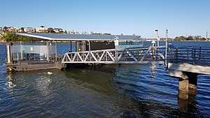
Drummoyne ferry wharf
Drummoyne ferry wharf (also known as Wolseley Street ferry wharf) is located on the southern side of the Parramatta River serving the Sydney suburb of Drummoyne. It served by Sydney Ferries Parramatta River services operating between Circular Quay and Parramatta.[1] The single wharf is served by RiverCat class ferries.
Drummoyne | |||||||||||||
|---|---|---|---|---|---|---|---|---|---|---|---|---|---|
 Wharf in January, 2018 | |||||||||||||
| Location | Wolseley Street, Drummoyne New South Wales Australia | ||||||||||||
| Coordinates | 33°50′43.77″S 151°9′25.55″E | ||||||||||||
| Owned by | Transport for NSW | ||||||||||||
| Operated by | Transdev Sydney Ferries | ||||||||||||
| Platforms | 1 wharf (1 berth) | ||||||||||||
| Construction | |||||||||||||
| Disabled access | Yes | ||||||||||||
| Other information | |||||||||||||
| Status | Unstaffed | ||||||||||||
| History | |||||||||||||
| Rebuilt | 17 September 2014 | ||||||||||||
| Previous names | Wolseley Street, Drummoyne (–2002) | ||||||||||||
| |||||||||||||
Upgrades
On 30 April 2014, the wharf closed for a five-month rebuild. The existing wharf was demolished, with a new one being built comprising a steel floating pontoon, a small concrete fixed entry platform and an aluminium gangway connecting the entry platform to the pontoon. It reopened on 17 September 2014.[2][3]
Wharves & services
| Platform | Line | Stopping pattern | Notes |
| 1 | Services to Circular Quay & Parramatta |
|---|
gollark: Pairing is annoying and doesn't really work.
gollark: It does NOT, in my experience.
gollark: Bluetooth for *light control*?
gollark: Why use discrete transistors when you could use several million on an IC?
gollark: But what if you want to be able to SSH into your ceiling lamps, ħmmmmm?
References
- F3 Timetable Transport for NSW
- Drummoyne Wharf set for major upgrade Transport for NSW 4 June 2013
- Drummoyne (Wolseley Street) Wharf Upgrade - Completed Roads & Maritime Services
External links
| Wikimedia Commons has media related to Drummoyne ferry wharf, Sydney. |
- Drummoyne Wharf at Transport for New South Wales (Archived 12 June 2019)
- Drummoyne Wharf Local Area Map Transport for NSW
This article is issued from Wikipedia. The text is licensed under Creative Commons - Attribution - Sharealike. Additional terms may apply for the media files.