Douglas Cave
Douglas Cave is a cave in the British Overseas Territory of Gibraltar.[1]
| Douglas Cave | |
|---|---|
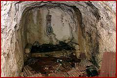 inside the cave | |
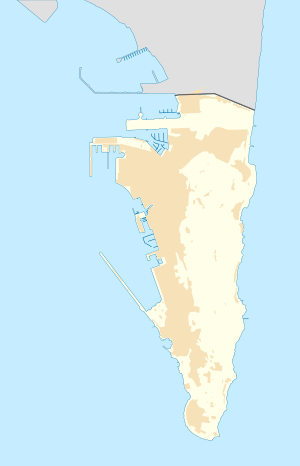 Map showing location in Gibraltar. | |
| Coordinates | 36°07′39.6″N 5°20′42.5″W |
Description
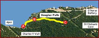
Douglas Path runs from A near the Charles V Wall past B World War II Observation Post and then down to Douglas Cave
Location
Douglas Cave is at the bottom of Douglas Path which runs north-south along the top ridge of the Rock of Gibraltar on the road leading up to O'Hara's Battery[2], all within the Upper Rock Nature Reserve.
History
First occupied during the Great Siege of Gibraltar (1779-1783)[3]. Re-occupied in 1940, the cave is, unusually, inside a brick building and contains a single stone seat and the remains of a simple plaque. The reason for this construction is unknown, although some upper rock camping experts believe it was used to store a high-powered searchlight during WWII.[4]
gollark: Which don't CATCH EVERYTHING.
gollark: It should be easy to do safe things and harder/warningier to do unsafe things.
gollark: Now yes, you can blame them for not being 1337 alpha programmers, or for using the wrong thing, but really it's partly a failing of C.
gollark: It makes it very easy to be unsafe, which I think should really be avoided, and yet people keep using it for stuff which really needs to not be unsafe.
gollark: No. Go away.
See also
References
| Wikimedia Commons has media related to Douglas Cave. |
- "Location of Caves - Gibraltar". Scribd. Retrieved 17 February 2013.
- "The Gibraltar Tunnels" by Tito Vallejo
- "The Gibraltar Tunnels" by Tito Vallejo
- "Douglas Path - see index". DiscoverGibraltar.com. Archived from the original on 5 September 2013. Retrieved 8 May 2013.
This article is issued from Wikipedia. The text is licensed under Creative Commons - Attribution - Sharealike. Additional terms may apply for the media files.