Dongola Airport
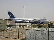
Dongola Airport (IATA: DOG, ICAO: HSDN; Arabic: مطار دنقلا) is an airport serving Dongola,[1] the capital city of the Northern state in Sudan.
Dongola Airport | |||||||||||
|---|---|---|---|---|---|---|---|---|---|---|---|
 | |||||||||||
| Summary | |||||||||||
| Airport type | Public | ||||||||||
| Serves | Dongola, Sudan | ||||||||||
| Elevation AMSL | 773 ft / 236 m | ||||||||||
| Coordinates | 19°09′13″N 030°25′48″E | ||||||||||
| Map | |||||||||||
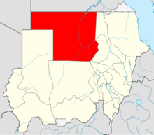 HSDN Location of airport in Sudan (Northern state highlighted) | |||||||||||
| Runways | |||||||||||
| |||||||||||
Facilities
The airport resides at an elevation of 773 feet (236 m) above mean sea level. It has one runway designated 17/35 with an asphalt surface measuring 3,000 by 45 metres (9,843 ft × 148 ft).[1]
Airlines and destinations
Template:SUDAN AIRWAYS
gollark: This is optimal.
gollark: Of course.
gollark: I am obviously reading out important files.
gollark: Actually, there is.
gollark: Interesting.
References
- Airport information for HSDN from DAFIF (effective October 2006)
- Airport information for DOG at Great Circle Mapper. Source: DAFIF (effective October 2006).
This article is issued from Wikipedia. The text is licensed under Creative Commons - Attribution - Sharealike. Additional terms may apply for the media files.