Dolní Podluží
Dolní Podluží, until 1947 Dolní Grund (German: Niedergrund) is a village and municipality (obec) in Děčín District in the Ústí nad Labem Region of the Czech Republic (not to be confused with Niedergrund an der Elbe).
Dolní Podluží | |
|---|---|
Municipality | |
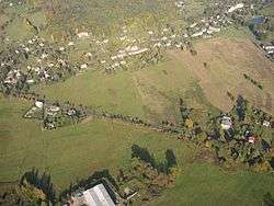 Aerial view | |
 Flag  Coat of arms | |
 Dolní Podluží | |
| Coordinates: 50°52′45″N 14°35′40″E | |
| Country | |
| Region | Ústí nad Labem |
| District | Děčín |
| Area | |
| • Total | 15.44 km2 (5.96 sq mi) |
| Elevation | 370 m (1,210 ft) |
| Population (2005) | |
| • Total | 1,199 |
| • Density | 78/km2 (200/sq mi) |
| Postal code | 407 55 |
| Website | http://www.dolnipodluzi.cz |
The municipality covers an area of 15.44 square kilometres (5.96 sq mi), and has a population of 1,199 (as at 2005).
Dolní Podluží lies approximately 32 kilometres (20 mi) north-east of Děčín, 46 km (29 mi) north-east of Ústí nad Labem, and 89 km (55 mi) north of Prague.
History
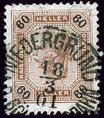
Until 1918, the town was part of the Austrian monarchy (Austria side after the compromise of 1867), in the RUMBURG (Rumburk) district, one of the 94 Bezirkshauptmannschaften in Bohemia.[1]
The town name changed from NIEDERGRUND BEI WARNSDORF in NIEDERGRUND A.D. BÖHMISCHE NORDBAHN in May 1883.
References
- Die postalischen Abstempelungen auf den österreichischen Postwertzeichen-Ausgaben 1867, 1883 und 1890, Wilhelm KLEIN, 1967
| Wikimedia Commons has media related to Dolní Podluží. |