Dobroslava
Dobroslava (Rusyn: Доброслава, Hungarian: Dobroszló) is a village and municipality in Svidník District in the Prešov Region of north-eastern Slovakia.
Dobroslava | |
|---|---|
Village and municipality | |
Wooden church in village | |
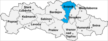
 Location of Svidník District in the Prešov Region. | |
| Coordinates: 49°22′N 21°37′E | |
| Country | |
| Region | Prešov Region |
| District | Svidník District |
| Area | |
| • Total | 5.577 km2 (2.153 sq mi) |
| • Land | 5.577 km2 (2.153 sq mi) |
| Elevation | 335 m (1,099 ft) |
| Population | |
| • Total | 139 |
| • Density | 25/km2 (65/sq mi) |
History
In historical records the village was first mentioned in 1600. The village is primarily inhabited by Rusyns.
Geography
The municipality lies at an altitude of 335 metres and covers an area of 5.577 km². It has a population of about 139 people.
Genealogical resources
The records for genealogical research are available at the state archive "Statny Archiv in Presov, Slovakia".
- Greek Catholic church records (births/marriages/deaths): 1860-1895 (parish B)
gollark: 🐝 72.█% of traditions.
gollark: Well, if you tarnish the reputation of the school horribly, their reasoning will no longer apply.
gollark: Do you have control of prestige?
gollark: What if you somehow make the yearbook non-prestigious?
gollark: There are a bunch of things for generating fake faces now; how do you *submit* a photo to the yearbook?
See also
- Dobrosława, a Slavic name
- List of municipalities and towns in Slovakia
External links
- https://web.archive.org/web/20071116010355/http://www.statistics.sk/mosmis/eng/run.html
- Surnames of living people in Dobroslava
This article is issued from Wikipedia. The text is licensed under Creative Commons - Attribution - Sharealike. Additional terms may apply for the media files.