Dhalaa
Dhalaa is a town and commune in Oum El Bouaghi Province, Algeria.
Dhalaa الضلعة | |
|---|---|
Commune and town | |
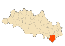 Location of the municipality in the wilaya of Oum El Bouaghi. | |
| Coordinates: 35.46111°N 7.547222°E | |
| Country | |
| Province | Oum El Bouaghi Province |
| Area | |
| • Total | 79 sq mi (205 km2) |
| Population (2008[1]) | |
| • Total | 11,439 |
| Time zone | UTC+1 (CET) |
Localities of the commune
The commune is composed of 21 localities [2] :
- Centre de Dhalâa
- Raf Raf
- Messlaf
- Benaïm
- Gabel Zebar
- Ouled Chamiekh
- Reggada
- Argoub Tine
- Gabel Lefdjidjet
- Dagher
- Fedj Tine
- Oglia
- Dhahret El Oued
- Gabel Boutekhma
- Argoub El Bey
- Henchir El Khadem
- Lekmine
- Ayoune Dekhakhène
- Lehguina
- Remaïdia
- Ras Zebar
- Kef El Aks
gollark: I have NO earphones!
gollark: Hi!
gollark: Okay, potatOS now has builtin `meta` support.
gollark: Mayhaps.
gollark: I should add this to potatOS... but where?
References
- "Wilaya d'Oum El Bouaghi : répartition de la population résidente des ménages ordinaires et collectifs, selon la commune de résidence et la dispersion" (PDF).. Données du recensement général de la population et de l'habitat de 2008 sur le site de l'ONS.
- "Décret n° 84-365, fixant la composition, la consistance et les limites territoriale des communes. Wilaya d`oum El Bouagh" [Decree n ° 84-365, fixing the composition, the consistency and the territorial limits of the communes. Wilaya d`oum El Bouagh] (PDF). Journal officiel de la République Algérienne (in French) (68): 1478. 19 December 1984. Retrieved 3 October 2019.
Capital: Oum El Bouaghi | ||
| Districts | .svg.png) | |
| Communes |
| |
This article is issued from Wikipedia. The text is licensed under Creative Commons - Attribution - Sharealike. Additional terms may apply for the media files.