Dantumadiel
Dantumadiel (formerly spelled as Dantumadeel) is a municipality in the province of Friesland (Fryslân) in the Netherlands. Dantumadiel is a rural municipality characterized by agriculture.
Dantumadiel | |
|---|---|
 Medieval church of Rinsumageast | |
 Flag Coat of arms | |
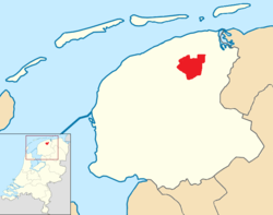 Location in Friesland | |
| Coordinates: 53°17′N 6°0′E | |
| Country | Netherlands |
| Province | Friesland |
| Government | |
| • Body | Municipal council |
| • Mayor | Klaas Agricola |
| Area | |
| • Total | 87.53 km2 (33.80 sq mi) |
| • Land | 85.41 km2 (32.98 sq mi) |
| • Water | 2.12 km2 (0.82 sq mi) |
| Elevation | 2 m (7 ft) |
| Population (January 2019)[4] | |
| • Total | 18,923 |
| • Density | 222/km2 (570/sq mi) |
| Time zone | UTC+1 (CET) |
| • Summer (DST) | UTC+2 (CEST) |
| Postcode | 9067, 9100–9114, 9269–9272 |
| Area code | 0511, 0519, 058 |
| Website | www |
History
The first time Dantumadiel is mentioned was in a document from 1242. At that time Dantumadiel, or Donthmadeil as it was then known, was a part of the Winninghe district, the northern part of Oostergo. The grietenij (municipality) Dantumadiel was led by a grietman (mayor) who was holding office in Rinsumageast and Dantumawâld. The Dutch Municipalities Act of 1851 (Dutch: Gemeentewet van 1851) abolished the grietenijen, which automatically became gemeenten (municipalities) headed by a mayor.
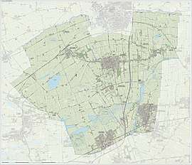
Population centres
The Dantumadiel municipality is composed of 11 towns with a total of 19,030 inhabitants in 2014; the towns and their 2014 populations are listed in the table.
| Name[5] | Residents[6] |
| Damwâld | 5,640 |
| De Westereen | 5,087 |
| Feanwâlden * | 3,521 |
| Broeksterwâld | 1,168 |
| Rinsumageast | 1,139 |
| Wâlterswâld | 993 |
| Driezum | 974 |
| De Falom | 265 |
| Readtsjerk | 198 |
| Sibrandahûs | 45 |
Source: Website Dantumadiel municipality
* Including Feanwâldsterwâl
Main sights
- Damwâld (Dantumawâld and Moarrewâld) and Rinsumageast, are home to medieval churches.
- The villages Broeksterwâld (Grutte Mûne and De Broekmolen) Rinsumageast and Readtsjerk are home to mills.
- The Skierstins a medieval fortified house in Feanwâlden.
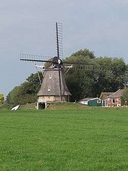 De Grote Molen, Broeksterwâld, built in 1887
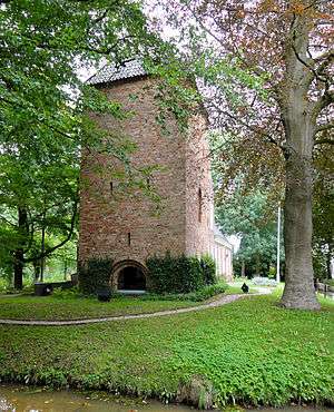 The Skierstins
Notable People

- Maria Petronella Woesthoven (1760 in Dantumawoude – 1830) a Dutch poet
- Tjeerd Pasma (1904 in Rinsumageast – 1944) a Dutch modern pentathlete, competed at the 1928 Summer Olympics
- Piet Jongeling (1909 in Broeksterwâld – 1985) journalist, politician and children's books writer
- Theun de Vries (1907 in Feanwâlden – 2005) writer and poet
- Jannes van der Wal (1956 in Driezum – 1996) a Dutch/Frisian draughts player
- Syb van der Ploeg (born 1966 in Dokkum) musician and composer
- Theo Pijper (born 1980 in Dokkum) a Dutch motorcycle speedway rider in the UK
Politics
The Dantumadiel municipal government consists of a municipal council, board of aldermen and the mayor. Klaas Agricola, (Dutch Wiki) has been the mayor of Dantumadiel since December 2017.
References
- "Burgemeester" [Mayor] (in Dutch). Gemeente Dantumadiel. Archived from the original on 13 October 2013. Retrieved 8 September 2013.
- "Kerncijfers wijken en buurten" [Key figures for neighbourhoods]. CBS Statline (in Dutch). CBS. 2 July 2013. Retrieved 12 March 2014.
- "Postcodetool for 9104BR". Actueel Hoogtebestand Nederland (in Dutch). Het Waterschapshuis. Retrieved 8 September 2013.
- "Bevolkingsontwikkeling; regio per maand" [Population growth; regions per month]. CBS Statline (in Dutch). CBS. 1 January 2019. Retrieved 1 January 2019.
- "Definitieve lijst Frysktalige straatnamen". Archived from the original on 2008-12-08. Retrieved 2009-01-01.
- "Gemeente Dantumadiel - Dorpen". Retrieved 2014-01-01.
External links
| Wikimedia Commons has media related to Dantumadiel. |
Places adjacent to Dantumadiel | |
|---|---|
| Administrative centre | 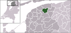 | |
|---|---|---|
| Villages | ||
| Hamlets and former villages |
| |
| Landmarks | ||
Municipalities of Friesland | ||
|---|---|---|
 | ||
| ||
| Authority control |
|---|