Dajabón
Dajabón is the capital city of the Dajabón province in the Dominican Republic, located on the border with Haiti. It is a market town with a population of about 40,000, north of the Cordillera Central mountain range.
Dajabón | |
|---|---|
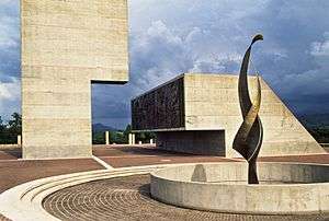
 Monument to the Dominican War of Restoration in Dajabon | |
 Seal | |
 Dajabón | |
| Coordinates: 19°34′0″N 71°42′36″W | |
| Country | Dominican Republic |
| Province | Dajabón |
| Founded | 1776 |
| Municipality | 1864 |
| Named for | Dajabón River |
| Area | 253.41 km2 (97.84 sq mi) |
| Elevation | 35 m (115 ft) |
| Population (2012)[3] | 25,983 |
| • Density | 100/km2 (270/sq mi) |
| • Urban | 18,725 |
| Including population of Cañongo. | |
| Climate | Aw |
The city was initially founded between 1771 and 1776 but was soon after abandoned during the War of Independence. It was settled again shortly after the Restoration War in 1865. During the 1822–44 Haitian occupation, the city was officially designated in French as Dahabon.
Dajabón is located on the Dajabón River, also known as the Massacre River due to an incident that took place in 1728 in which 30 French Buccaneers were killed by Spanish settlers.[4]
A battle that took place here between the Spanish and the French in 1690. At the time of this battle, the governor of the French colony, Mr. Cussy, was killed in the Battle of the Sabana Real de la Limonada, near modern-day Limonade in northern Haiti.[5] The bridge across the river connects Dajabón to its larger Haitian sister city of Ouanaminthe. On Mondays and Fridays, Haitians are permitted to temporarily cross the bridge to sell their goods. Most of the goods are used clothes, shoes, bulk dry goods, and housewares. On these days, an area of several acres on the Western edge of the city becomes a crowded business place. In addition to the Haitians, Dominicans go to the market to sell food (vegetables grown in their part of the country).
Climate
| Climate data for Dajabón (1961–1990) | |||||||||||||
|---|---|---|---|---|---|---|---|---|---|---|---|---|---|
| Month | Jan | Feb | Mar | Apr | May | Jun | Jul | Aug | Sep | Oct | Nov | Dec | Year |
| Record high °C (°F) | 33.5 (92.3) |
35.5 (95.9) |
38.2 (100.8) |
35.4 (95.7) |
37.0 (98.6) |
36.5 (97.7) |
36.5 (97.7) |
39.0 (102.2) |
37.5 (99.5) |
35.2 (95.4) |
37.0 (98.6) |
35.0 (95.0) |
39.0 (102.2) |
| Average high °C (°F) | 29.3 (84.7) |
29.9 (85.8) |
30.6 (87.1) |
30.7 (87.3) |
31.1 (88.0) |
32.3 (90.1) |
33.2 (91.8) |
33.3 (91.9) |
32.9 (91.2) |
31.9 (89.4) |
30.4 (86.7) |
29.2 (84.6) |
31.2 (88.2) |
| Average low °C (°F) | 17.6 (63.7) |
17.9 (64.2) |
18.8 (65.8) |
19.8 (67.6) |
21.0 (69.8) |
21.8 (71.2) |
21.5 (70.7) |
21.7 (71.1) |
21.7 (71.1) |
21.3 (70.3) |
20.0 (68.0) |
18.3 (64.9) |
20.1 (68.2) |
| Record low °C (°F) | 11.0 (51.8) |
11.0 (51.8) |
12.5 (54.5) |
13.0 (55.4) |
14.0 (57.2) |
17.5 (63.5) |
17.5 (63.5) |
16.0 (60.8) |
17.0 (62.6) |
17.0 (62.6) |
13.0 (55.4) |
12.0 (53.6) |
11.0 (51.8) |
| Average rainfall mm (inches) | 34.0 (1.34) |
32.1 (1.26) |
48.2 (1.90) |
77.6 (3.06) |
182.8 (7.20) |
161.0 (6.34) |
99.9 (3.93) |
110.3 (4.34) |
149.3 (5.88) |
138.7 (5.46) |
74.4 (2.93) |
59.1 (2.33) |
1,167.4 (45.96) |
| Average rainy days (≥ 1.0 mm) | 4.3 | 2.8 | 3.5 | 5.7 | 10.8 | 10.8 | 7.8 | 8.4 | 10.7 | 10.3 | 6.1 | 4.1 | 85.3 |
| Average relative humidity (%) | 79.6 | 78.2 | 76.6 | 76.4 | 79.9 | 79.9 | 78.2 | 78.4 | 79.7 | 81.1 | 80.7 | 80.0 | 79.1 |
| Source: NOAA[6] | |||||||||||||
External links
- Dajabon, Encyclopædia Britannica
References
- Superficies a nivel de municipios, Oficina Nacional de Estadistica Archived April 17, 2009, at the Wayback Machine
- De la Fuente, Santiago (1976). Geografía Dominicana (in Spanish). Santo Domingo, Dominican Republic: Editora Colegial Quisqueyana.
- Censo 2012 de Población y Vivienda, Oficina Nacional de Estadistica
- "Massacre River". Haiti Observer. Retrieved 2017-05-08.
- "Gobernadores de la Isla de Santo Domingo (see page 375 for information on the battle of the Sabana Real de la Limonada in 1690)" (PDF). Archived from the original (PDF) on 2014-02-10. Retrieved 2014-06-27.
- "Dajabon Climate Normals 1961-1990". National Oceanic and Atmospheric Administration. Retrieved September 12, 2016.