Dahab Island
Dahab Island (or: Gazirat edh-Dhahab, Arabic: جزيرة الذهب, Ǧazīrat aḏ-Ḏahab, "Island of Gold") is a Nile island located in the metropolitan region of Cairo near the eastern Nile shore south of Roda Island and near of Qorsaya Island. The island belongs to Giza and has a strong agricultural character.[1]
| Native name: جزيرة الذهب | |
|---|---|
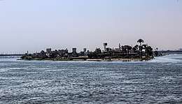 Northern part of Dahab Island with al-Munib bridge in the background | |
 Dahab Island Location in Egypt | |
| Geography | |
| Location | Nile River |
| Coordinates | 29.982°N 31.224°E |
| Adjacent bodies of water | Nile |
| Length | 4,200 m (13,800 ft) |
| Administration | |
Egypt | |
The 4,200-metre-long (2.6 mi) Dahab Island is inhabited by roughly 11,000 fishermen and farmers. The island is accessed by ferry.
There is an open conflict between the island residents and the Cairo-development plan of the Egyptian government.[2]
References
This article is issued from Wikipedia. The text is licensed under Creative Commons - Attribution - Sharealike. Additional terms may apply for the media files.