Dabusun Lake
Dabusun or Dabuxun Lake, alternately known as Dabasun Nor, is a lake beside the town Qarhan, just north of Golmud in the Haixi Prefecture of Qinghai Province in northwestern China. Fed by the main course of the Golmud River, it is the largest present-day lake in the Qarhan Playa. Like the other lakes of the surrounding Qaidam Basin, it is extremely saline, with 307–338 grams of salt per liter of water (2.5 lb/gallon).
| Dabusun Lake | |
|---|---|
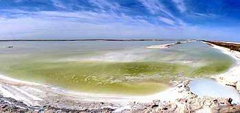 Dabusun Lake (2006) | |
 Dabusun Lake | |
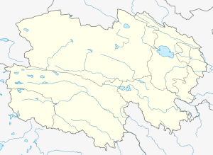
| Location | Golmud City Haixi Prefecture Qinghai Province China |
| Coordinates | 37°01′27″N 95°08′20″E |
| Type | Endorheic saline lake |
| Native name |
|
| Primary inflows | Golmud River |
| Basin countries | China |
| Max. length | 30 km (19 mi) |
| Max. width | 4–7.5 km (2–5 mi) |
| Surface area | 184–334 km2 (71–129 sq mi) |
| Average depth | 0.5–1.02 m (1 ft 8 in–3 ft 4 in) |
| Max. depth | 1.72 m (5 ft 8 in) |
| Surface elevation | 2,675 m (8,776 ft) |
| Dabusun Lake | |||||||||
|---|---|---|---|---|---|---|---|---|---|
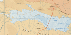 A map of Dabusun Lake in the central Qarhan Playa (1975) | |||||||||
| Chinese name | |||||||||
| Traditional Chinese | 達布遜鹽湖 | ||||||||
| Simplified Chinese | 达布逊盐湖 | ||||||||
| Postal | Dabasun Nor | ||||||||
| Literal meaning | Dabusun Salt Lake | ||||||||
| |||||||||
| Mongolian name | |||||||||
| Mongolian script | (ᠵᠡᠭᠦᠨ) ᠳᠠᠪᠤᠰᠤᠨ ᠨᠠᠭᠤᠷ | ||||||||
| |||||||||
| Former names | |||||
|---|---|---|---|---|---|
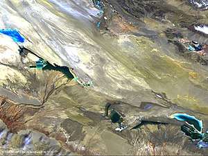 The Sanhu Depression in 2014, with Dabusun in the southeast (ESA) | |||||
| Mongolian name | |||||
| Mongolian script | ᠳᠠᠯᠠᠢ ᠳᠠᠪᠤᠰᠤᠨ | ||||
| |||||
Name
Dabusun[1][2] or Dabasun Nor[3][4][5] is a romanization of its Mongolian name, which means simply "Salt Lake".[6] In Mongolian, the name is sometimes designated "eastern", to distinguish it from West Dabusun Lake.[6] It is sometimes misspelled Dabsun[7] or Dabsan.[8][9] It was formerly known as the Dalai Dabasun,[10] meaning "Sea" or "Ocean of Salt".
Dabuxun[7] is the pinyin romanization of the Chinese name 達布遜 (Dábùxùn), a transcription into characters of the Mongolian name.
Geography
Dabusun lies in the Dabusun subbasin in the central Qarhan Playa.[11] It is one of the many saltwater lakes in the endorheic Qaidam Basin,[7] bound by the Qilian Mountains to the north, the Altun to the west, and the Kunlun to the south.[12] Lying at an elevation of 2,675 m (8,776 ft) above sea level, it has a mean annual temperature of 0.1 °C (32.2 °F) despite lying on the same latitude as Greece, Algeria, and Virginia in the United States.[8] Dabasun is the largest present lake in the Qarhan Playa.[7] It is fed by the main course of the Golmud River from the south and, to a lesser extent, by mineral springs[2] from the north.[13] In Qaidam's hyperarid climate, there is generally only 28–40 mm (1–2 in) of annual rainfall but about 3,000 mm (120 in) of annual evaporation.[8] Its area is thus variable by season and year,[14] usually 184–334 km2 (71–129 sq mi) but increasing in the wetter winter and spring and decreasing through the summer and fall. The lake is elongated, stretching from the northwest to the southeast. Its length is usually about 30 km (19 mi) east to west, and its width is usually about 4–7.5 km (2–5 mi) north to south. The maximum depth is 1.72 m (5 ft 8 in), and the average depth varies from 0.5 to 1.02 m (1 ft 8 in to 3 ft 4 in).
Geology
Although the northern springs contribute much less volume, their waters carry far greater concentrations of solutes and are important to the chemical composition of the lake.[15] Below, the alternating beds of mud and halite extend at least 40 m (130 ft) in some places.[7] In addition to common salt, it also has an abundance of carnallite[1] (potassium magnesium chloride) in an area of 2 km × 35 km (1 mi × 22 mi) and magnesium sulfate. The known beds are exposed at the surface or buried by 3–4 m (10–13 ft) of sedimentation.[7]
History
Paleoclimatologists believe that between 770,000 and 30,000 years ago Dabusun formed part of a much larger Qarhan Lake, which alternated nine times between being a fresh- and saltwater lake.[16] Pollen studies suggest that the area of the lake bed which now underlies Dabusun was raised around 700 m (2,300 ft) in just the last 500,000 years.[17] Tectonic activity also varied sedimentation in the lake by shifting its tributaries and basins, although it remained in the Qarhan Playa during this period.[18] At around 30,000 years ago, this great freshwater lake spread over at least 25,000 km2 (9,700 sq mi) with a surface 50–60 m (160–200 ft) above the present levels of its successors. It was cut off and became saline again around 30,000 years ago and began precipitating salts about 25,000 years ago.[19] It has been shrinking in size by evaporation for most of that time,[10] although it was only about 42 km (26 mi) in circumference in the mid-19th century, when it was visited by the Polono-Russian explorer Przhevalsky.[10][lower-alpha 1]
Until the recent commercial exploitation of the salts and other minerals, the district has remained largely unpopulated, as the salt deposits made it difficult for the nomads of northwestern China to use the area for their herds.[10] The area's potassium deposits were accidentally discovered in 1957[21] and exploratory wells found the Yanhu Gas Field north of the lake the next year.[22]
Transportation
The lake lies just west of the G3011 Liuge Expressway. It is also serviced by the Dabusun and Qarhan railway stations on the Qingzang Railway.
See also
Notes
References
Citations
- Casas & al. (1992).
- Lowenstein & al. (1994), p. 20.
- Geogr. Journ. (1908), p. 442.
- Stanford (1917), p. 21.
- Chambers Encyclopaedia (1968), Vol. XV, p. 189.
- Jia (2019).
- Garrett (1996), p. 177.
- Yu & al. (2001), p. 62.
- Zhang & al. (1990).
- Ward (1878), p. 250.
- Du & al. (2018), pp. 2–3.
- Casas & al. (1992), p. 882.
- Spencer & al. (1990), pp. 397–399.
- Zhou & al. (2016), pp. 4 & 6.
- Spencer & al. (1990), pp. 398–399.
- Huang & al. (1997), p. 277.
- Jiang & al. (2000), pp. 96 & 106.
- Kong & al. (2018), §2.
- Zheng (1997), p. 149.
- Ward (1878), p. 251.
- Shan (2010).
- Yang & al. (2012), p. 33.
Bibliography
- "The Monthly Record", The Geographical Journal, 31 (4): 438–451, 1908, JSTOR 1777861.
- Casas, Enrique; et al. (1992), "Carnallite Mineralization in the Nonmarine, Qaidam Basin, China: Evidence for the Early Diagenetic Origin of Potash Evaporites", SEPM Journal of Sedimentary Research, 62 (5): 881–898, doi:10.1306/D4267A05-2B26-11D7-8648000102C1865D.
- Du, Yongsheng; et al. (2019), "Evaluation of boron isotopes in halite as an indicator of the salinity of Qarhan paleolake water in the eastern Qaidam Basin, western China", Geoscience Frontiers, 10: 253–262, Bibcode:2019AGUFM.V33C0255D, doi:10.1016/j.gsf.2018.02.016.
- Garrett, Donald Everett (1996), Potash: Deposits, Processing, Properties, and Uses, London: Chapman & Hall, ISBN 9789400915459.
- Jia Xiru (20 February 2019), "Qīnghǎi Měnggǔyǔ Dìmíng de Jǐge Tèsè 青海蒙古語地名的幾個特色 [Several Characteristics of Mongolian Placenames in Qinghai]", Xuěhuā Xīnwén 雪花新闻 [Snowflake News] (in Chinese).
- Dexin, J. (2000), "Quaternary Palynofloras and Paleoclimate of the Qaidam Basin, Qinghai Province, Northwestern China", Palynology, 24: 95–112, doi:10.2113/0240095.
- Qi, Huang; et al. (1997), "Stable isotopes distribution in core Ck6 and variations of paleoclimate over Qarhan Lake region in Qaidam Basin, China", Chinese Journal of Oceanology and Limnology, 15 (3): 271–278, Bibcode:1997ChJOL..15..271H, doi:10.1007/BF02850884.
- Kong, Fanjing; et al. (2018), "Dalangtan Saline Playa in a Hyperarid Region on Tibet Plateau: I. Evolution and Environments", Astrobiology, 18 (10): 1243–1253, Bibcode:2018AsBio..18.1243K, doi:10.1089/ast.2018.1830, PMC 6205091, PMID 29792755.
- Lowenstein, Timothy K.; et al. (1994), "Major-Element and Stable-Isotope Geochemistry of Fluid Inclusions in Halite, Qaidam Basin, Western China: Implications for Late Pleistocene/Holocene Brine Evolution and Paleoclimates", in Rosen, Michael R. (ed.), Paleoclimate and Basin Evolution of Playa Systems, Special Paper, No. 289, Boulder: Geological Society of America, pp. 19–32, ISBN 9780813722894.
- Shan Zhiqiang (31 May 2010), "Qarhan Salt Lake: Drying Yard of the Heavens", Shanghai Daily.
- Spencer, Ronald James; et al. (1990), "Origin of Potash Salts and Brines in the Qaidam Basin, China" (PDF), Fluid-Mineral Interactions: A Tribute to H.P. Eugster, Special Publication No. 2, Geochemical Society.
- Stanford, Edward (1917), Complete Atlas of China, 2nd ed., London: China Inland Mission.
- Ward, Thomas (1878), "On 'The Salt Lakes, Deserts, and Salt Districts of Asia,' with a Map", Proceedings of the Literary and Philosophical Society of Liverpool during the Sixty-Seventh Session, 1877–78, 32, Liverpool: D. Marples & Co, pp. 233–256.
- Yang, Hui; et al. (2012), "Integrated geophysical studies on the distribution of Quaternary biogenic gases in the Qaidam Basin, NW China", Petroleum Exploration and Development, 39 (1): 33–42, doi:10.1016/S1876-3804(12)60012-3.
- Yu, Ge; et al. (2001), Lake Status Records from China: Data Base Documentation (PDF), MPI-BGC Tech Rep, No. 4, Jena: Max Planck Institute for Biogeochemistry.
- Zhang Baozhen; et al. (1990), "Hydrogen and Oxygen Stable Isotope Analyses of Fluid Inclusions in Halite in Charhan Salt Lake with Geochemical Implications", Acta Sedimentologica Sinica, 8 (1): 3–17.
- Zheng Mianping (1997), An Introduction to Saline Lakes on the Qinghai–Tibet Plateau, Dordrecht: Kluwer Academic Publishers, ISBN 9789401154581.
- Zhou, S. L.; et al. (2016), "Spatial-temporal variations and their dynamics of the saline lakes in the Qaidam Basin over the past 40 years", IOP Conference Series: Earth and Environmental Science, 46 (1): 012043, Bibcode:2016E&ES...46a2043Z, doi:10.1088/1755-1315/46/1/012043.
External links
- 《达布逊盐湖》 at Baidu Baike (in Chinese)