Dębniki (Kraków)
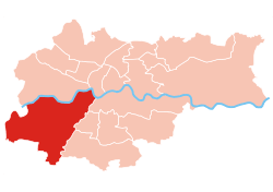
Dębniki is one of 18 districts of Kraków, located in the southwest part of the city. The name Dębniki comes from a village of same name that is now a part of the district.
Dębniki | |
|---|---|
 | |
 Location of Dębniki within Kraków | |
| Coordinates: 50°2′0″N 19°53′0″E | |
| Country | |
| Voivodeship | Lesser Poland |
| County/City | Kraków |
| Government | |
| • President | Arkadiusz Puszkarz |
| Area | |
| • Total | 46.19 km2 (17.83 sq mi) |
| Population (2014) | |
| • Total | 59,395 |
| • Density | 1,300/km2 (3,300/sq mi) |
| Time zone | UTC+1 (CET) |
| • Summer (DST) | UTC+2 (CEST) |
| Area code(s) | +48 12 |
| Website | http://www.dzielnica8.krakow.pl |
According to the Central Statistical Office data, the district's area is 46.19 square kilometres (17.83 square miles) and 59 395 people inhabit Dębniki.[1]
Subdivisions of Dębniki
Dębniki is divided into smaller subdivisions (osiedles). Here's a list of them.
- Ruczaj
- Osiedle Europejskie
- Osiedle Interbud
- Osiedle Zielona Galicja
- Osiedle Kolejowe
- Osiedle Panorama
- Kliny Zacisze
- Mochnaniec
- Skotniki
- Tyniec
- Zakrzówek
- Kapelanka
Population

gollark: Instead you get Microsoft not allowing approved stuff to boot. Unless you disable that setting.
gollark: UEFI at least removes the booting-in-16-bit mode thing!
gollark: We could make a page for it presenting it as one.
gollark: With UEFI.
gollark: To be fair, 64 bit machines actually will boot as 64 bit now.
References
- "Information about Dębniki district". Biuletyn Informacji Publicznej. Retrieved 30 August 2017.
External links
| Wikimedia Commons has media related to District VIII Dębniki (Kraków). |
This article is issued from Wikipedia. The text is licensed under Creative Commons - Attribution - Sharealike. Additional terms may apply for the media files.