Cowrock Mountain
Cowrock Mountain is a mountain that is located in Lumpkin and White counties in Georgia. The mountain forms a north/south ridge. Its northern peak, Cowrock, has an elevation of 3,852 feet (1,174 m) and its southern peak, Cowrock Flat, has an elevation of 3,502 feet (1,067 m). The boundary line between Lumpkin and White counties follows the ridge formed by Cowrock Mountain. The peak called Cowrock is the highest point in Lumpkin County, forms the northeast corner of the county. The Appalachian Trail also crosses Cowrock Mountain. The mountain is located within the Raven Cliffs Wilderness in the Chattahoochee National Forest.
| Cowrock Mountain | |
|---|---|
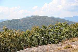 Cowrock Mountain viewed from Wildcat Mountain | |
| Highest point | |
| Elevation | 3,852 ft (1,174 m) |
| Coordinates | 34°43′18″N 83°51′24″W |
| Geography | |
| Location | Lumpkin / White counties, Georgia, U.S. |
| Parent range | Blue Ridge Mountains |
| Topo map | USGS Cowrock |
| Climbing | |
| First ascent | unknown |
| Easiest route | Appalachian Trail |
Sources
gollark: I think I have more than 89 already.
gollark: I mean, Nix can already do that, people just don't like it.
gollark: You need more than a very limited package manager frontend for this.
gollark: If you're installing it yourself, you *probably* should know what package manager is in use so you know how to update it and such.
gollark: And configuration.
External links
| Wikimedia Commons has media related to Cowrock Mountain. |
This article is issued from Wikipedia. The text is licensed under Creative Commons - Attribution - Sharealike. Additional terms may apply for the media files.