Continental drip
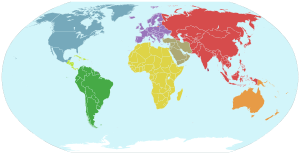
Continental drip is the observation that southward-pointing landforms are more numerous and prominent than northward-pointing landforms. For example, Africa, South America, India etc. all taper off to a point towards the south. The name is a play on continental drift.

In a classic map of the world (with north at the top), the southern ends of the continental landmasses appear to "drip" downward.
The observation was made by Ormonde de Kay in a 1973 tongue-in-cheek paper.[1] John C. Holden expanded and illustrated his own version of the idea in 1976.[2]
The planet simulator (software toy) SimEarth by Maxis includes continental drip in its Terran (Earth) simulations.
References
- de Kay, Jr., Ormonde (1982) [condensed from Horizon. Winter 1973.]. "Continental Drip". In Weber, Robert L. (ed.). More Random Walks in Science. CRC Press. pp. 201–203. ISBN 978-0854980406..
- Holden, John C. (October 1, 2001) [originally in Journal of Irreproducible Results. 22 (2). July 1976.]. "Fake Tectonics and Continental Drip". In Simanek, Donald M.; Holden, John (eds.). Science Askew: A Light-hearted Look at the Scientific World. (Institute of Physics Conference Series). CRC Press. pp. 40–42. ISBN 978-0750307147.
This article is issued from Wikipedia. The text is licensed under Creative Commons - Attribution - Sharealike. Additional terms may apply for the media files.