Cono Norte
The Cono Norte (recently being called Lima Norte) is one of the six areas that make up the Lima Metropolitan Area. It is located in the northern part of the metropolis, hence its name. The socioeconomic levels of its residents are varied. Ancón and Santa Rosa (both in the far north of the province) are popular beach resorts (but not residential areas) for wealthier residents of Lima. The rest of the population comprises middle class and lower class residents. It is one of the most populated areas of Peru.
Cono Norte | |
|---|---|
Sector | |
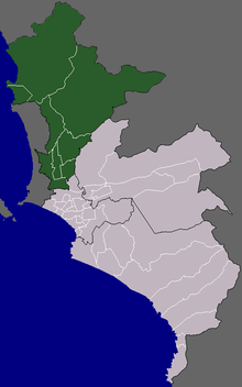 Location of Cono Norte in the Lima province | |
| Country | Peru |
| Region | Lima |
| Province | Lima |
| Districts | Ancón, Carabayllo, Comas, Independencia, Los Olivos, Puente Piedra, San Martín de Porres, Santa Rosa |
| Area | |
| • Total | 988.5 km2 (381.7 sq mi) |
| Elevation | 238 m (781 ft) |
| Population | |
| • Total | 2,732,943 |
| • Density | 2,800/km2 (7,200/sq mi) |
| Time zone | UTC-5 (PET) |
Districts
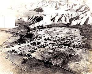
Puente Piedra in 1930
The following districts are part of the Cono Norte:[1]
- Ancón
- Carabayllo
- Comas
- Independencia
- Los Olivos (unofficial capital)
- Puente Piedra
- San Martín de Porres
- Santa Rosa
gollark: You can in fact play music and have other websites open simultaneously.
gollark: The software side is trivial but you have to write a lot of """good""" questions.
gollark: I could write my own if I could be bothered, which I cannot.
gollark: I mostly support all technology ever, but I think their questions about it were silly.
gollark: Oh wait, I actually can edit my results, nice.
References
- (in Spanish) INEI, Characteristics per Cono and District, Retrieved October 31, 2007.
External links

This article is issued from Wikipedia. The text is licensed under Creative Commons - Attribution - Sharealike. Additional terms may apply for the media files.