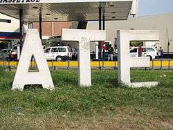
Ate District
Ate, also known as Ate-Vitarte, is a district of the Lima Province in Peru. Located in the eastern part of the province, it is one of the districts that comprise the city of Lima.
Ate | |
|---|---|
 | |
 Coat of arms | |
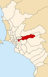 Location of Ate in Lima | |
| Coordinates: 12°00′37″S 76°52′12″W | |
| Country | |
| Region | Lima |
| Province | Lima |
| Capital | Vitarte |
| Government | |
| • Mayor | Edde Cuellar Alegría (2019-2022) |
| Area | |
| • Total | 77.72 km2 (30.01 sq mi) |
| Elevation | 355 m (1,165 ft) |
| Population (2017) | |
| • Total | 599,196 |
| • Density | 7,700/km2 (20,000/sq mi) |
| Time zone | UTC-5 (PET) |
| UBIGEO | 150103 |
| Website | muniate.gob.pe |
History
Geography
The district has a total land area of 77.72 km². Its administrative center is located 355 meters above sea level.
Boundaries
- North: Lurigancho
- East: Santa Anita, Chaclacayo, Cieneguilla
- South: Santiago de Surco, La Molina
- West: San Borja, San Luis
Demographics
According to the 2007 census by the INEI, the district has 478,278 inhabitants and a population density of 6,154 persons/km². In 2005, there were 105,190 households in the district. It is the 13th most populated district in Lima.
Points of interest
- Stadium "Estadio Monumental de Universitario de Deportes", home of one of the most popular football teams in Perú.
- Puruchuco Archeological Site
- Huaycan Archeological Site
- Cahuide Park
gollark: An "anti-reddit spam language" or something?
gollark: That is an interesting idea actually, yes.
gollark: In what language?
gollark: Maybe you could make some sort of fancy tool to automatically try and flatten stuff into fewer dimensions. Although this *may* be somewhat impossible.
gollark: So it's stored as... a mapping from dimension to position instead?
See also
External links
| Wikimedia Commons has media related to Ate District. |
This article is issued from Wikipedia. The text is licensed under Creative Commons - Attribution - Sharealike. Additional terms may apply for the media files.