Colcabamba District, Tayacaja
Colcabamba (from Quechua: Qullqa Pampa, meaning "deposit plain") is one of sixteen districts of the Tayacaja Province in Peru.[1]
Colcabamba Qullqa Pampa | |
|---|---|
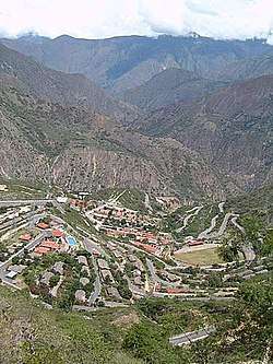 Campo Armiño, Colcabamba District | |
 Coat of arms | |
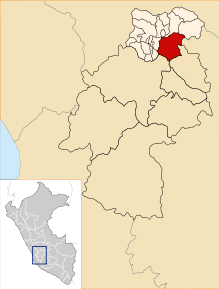 Location of Colcabamba in the Tayacaja province | |
| Coordinates: 12°24.5′S 74°40.6′W | |
| Country | |
| Region | Huancavelica |
| Province | Tayacaja |
| Capital | Colcabamba |
| Government | |
| • Mayor | Augusto Maravi Romani |
| Area | |
| • Total | 598.12 km2 (230.94 sq mi) |
| Elevation | 2,979 m (9,774 ft) |
| Population (2005 census) | |
| • Total | 21,593 |
| • Density | 36/km2 (94/sq mi) |
| Time zone | UTC-5 (PET) |
| UBIGEO | 090705 |
Geography
One of the highest peaks of the district is Atuq Punta at approximately 4,400 m (14,400 ft). Other mountains are listed below:[2]
- Arpayuq
- Ch'uñuna Mach'ay
- Kimsa Chumpi
- Minas Qucha
- Pakay Raqra
- Panti
- Parya Qaqa
- Pawkaray
- Qillwa Qucha
- Q'illu Qucha
- Tayanku
- Wanu Pata
- Waylla
- Wiska
Ethnic groups
The people in the district are mainly indigenous citizens of Quechua descent. Quechua is the language which the majority of the population (76.32%) learnt to speak in childhood, 23.21% of the residents started speaking using the Spanish language (2007 Peru Census).[3]
gollark: No use randomly writing mathematical code for a random platform when I have no idea what to do with it.
gollark: I don't see why I would want that, and that's not listed, but I imagine you could implement it.
gollark: <@201096871341588480> Actually, I might as well just link you the docs, this lists all the stuff it can do in MicroPython: https://microbit-micropython.readthedocs.io/en/v1.0.1/microbit_micropython_api.html
gollark: Help make the communist revolution more inevitable and use "comrades"!
gollark: Built-in, text display (on a 5x5 LED matrix...), buttons, image handling (for said 5x5 LED matrix), GPIO pin access, music and also raw audio (external speaker needed, I have one), speech synthesis (???), random numbers, accelerometer access/gesture control, compass/magnetometer access, persistent data storage, UART, SPI, and radio access.
References
- (in Spanish) Instituto Nacional de Estadística e Informática. Banco de Información Distrital Archived April 23, 2008, at the Wayback Machine. Retrieved April 11, 2008.
- escale.minedu.gob.pe/ UGEL map Tayacaja Province (Apurímac Region) 2017
- inei.gob.pe Archived January 27, 2013, at the Wayback Machine INEI, Peru, Censos Nacionales 2007, Frequencias: Preguntas de Población: Idioma o lengua con el que aprendió hablar (in Spanish)
| |
|---|---|
| Acobamba | |
| Angaraes | |
| Castrovirreyna | |
| Churcampa | |
| Huancavelica | |
| Huaytará | |
| Tayacaja | |
This article is issued from Wikipedia. The text is licensed under Creative Commons - Attribution - Sharealike. Additional terms may apply for the media files.