Christine, Texas
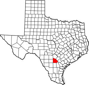
Christine is a town in Atascosa County, Texas, United States. The population was 390 at the 2010 census.[5] It is part of the San Antonio Metropolitan Statistical Area.
Christine, Texas | |
|---|---|
Location of Christine, Texas | |
 | |
| Coordinates: 28°47′23″N 98°29′49″W | |
| Country | United States |
| State | Texas |
| County | Atascosa |
| Area | |
| • Total | 1.72 sq mi (4.45 km2) |
| • Land | 1.72 sq mi (4.45 km2) |
| • Water | 0.00 sq mi (0.00 km2) |
| Elevation | 331 ft (101 m) |
| Population (2010) | |
| • Total | 390 |
| • Estimate (2019)[2] | 425 |
| • Density | 247.24/sq mi (95.45/km2) |
| Time zone | UTC-6 (Central (CST)) |
| • Summer (DST) | UTC-5 (CDT) |
| ZIP code | 78012 |
| Area code(s) | 830 |
| FIPS code | 48-14860[3] |
| GNIS feature ID | 1354476[4] |
Etymology
In October 1910, the town of "New Artesia" was to be incorporated. When the papers were presented in Austin, the men who took them there were told that they would have to change the name since there was already a town in West Texas with that name. The men returned home, called a town meeting and asked for suggestions. Not having any luck, the city council members finally authorized their wives to choose a suitable name. The ladies renamed New Artesia "Christine" after Christine Andrews, the first baby girl born in the town. She was the daughter of City Marshal James Andrews and wife, Rieta. The corrected papers were taken back to Austin and Christine was incorporated on October 22, 1910. There is an incorrect rumor that the town was named after Dr. Charles Simmons' daughter.
Geography
Christine is located at 28°47′23″N 98°29′49″W (28.789626, -98.497018),[6] 10 miles (16 km) south of Jourdanton, the county seat.
According to the United States Census Bureau, the town has a total area of 1.8 square miles (4.7 km2), all land.
Demographics
| Historical population | |||
|---|---|---|---|
| Census | Pop. | %± | |
| 1920 | 259 | — | |
| 1930 | 524 | 102.3% | |
| 1940 | 286 | −45.4% | |
| 1950 | 289 | 1.0% | |
| 1960 | 276 | −4.5% | |
| 1970 | 289 | 4.7% | |
| 1980 | 392 | 35.6% | |
| 1990 | 368 | −6.1% | |
| 2000 | 436 | 18.5% | |
| 2010 | 390 | −10.6% | |
| Est. 2019 | 425 | [2] | 9.0% |
| U.S. Decennial Census[7] | |||
As of the census[3] of 2000, there were 436 people, 140 households, and 116 families residing in the town. The population density was 248.0 people per square mile (95.6/km2). There were 160 housing units at an average density of 91.0 per square mile (35.1/km2). The racial makeup of the town was 78.90% White, 0.23% Asian, 14.91% from other races, and 5.96% from two or more races. Hispanic or Latino people of any race were 74.54% of the population.
There were 140 households, out of which 48.6% had children under the age of 18 living with them, 65.0% were married couples living together, 12.9% had a female householder with no husband present, and 17.1% were non-families. 17.1% of all households were made up of individuals, and 8.6% had someone living alone who was 65 years of age or older. The average household size was 3.11 and the average family size was 3.50.
In the town, the population was spread out, with 37.6% under the age of 18, 6.9% from 18 to 24, 29.6% from 25 to 44, 15.8% from 45 to 64, and 10.1% who were 65 years of age or older. The median age was 30 years. For every 100 females, there were 96.4 males. For every 100 females age 18 and over, there were 92.9 males.
The median income for a household in the town was $23,333, and the median income for a family was $25,375. Males had a median income of $23,333 versus $13,281 for females. The per capita income for the town was $10,465. About 34.5% of families and 38.3% of the population were below the poverty line, including 47.4% of those under age 18 and 36.2% of those age 65 or over.
Education
Christine is served by the Jourdanton Independent School District.
References
- "2019 U.S. Gazetteer Files". United States Census Bureau. Retrieved August 7, 2020.
- "Population and Housing Unit Estimates". United States Census Bureau. May 24, 2020. Retrieved May 27, 2020.
- "U.S. Census website". United States Census Bureau. Retrieved 2008-01-31.
- "US Board on Geographic Names". United States Geological Survey. 2007-10-25. Retrieved 2008-01-31.
- "Geographic Identifiers: 2010 Demographic Profile Data (G001): Christine town, Texas". U.S. Census Bureau, American Factfinder. Archived from the original on February 10, 2020. Retrieved August 26, 2013.
- "US Gazetteer files: 2010, 2000, and 1990". United States Census Bureau. 2011-02-12. Retrieved 2011-04-23.
- "Census of Population and Housing". Census.gov. Retrieved June 4, 2015.
