Chiquián District
Chiquián is a district of the province of Bolognesi, in the Ancash Region of Peru.[1]
Chiquián Chiqllan | |
|---|---|
 | |
| Country | |
| Region | Ancash |
| Province | Bolognesi |
| Capital | Chiquián |
| Government | |
| • Mayor | Gudberto Carrera Padilla |
| Area | |
| • Total | 184.16 km2 (71.10 sq mi) |
| Elevation | 4,023 m (13,199 ft) |
| Population (2017) | |
| • Total | 4,508 |
| • Density | 24/km2 (63/sq mi) |
| Time zone | UTC-5 (PET) |
| UBIGEO | 020501 |
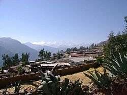
It is located on the Nor-Eastern part of the Bolognesi Province, Ancash Department in Peru. Its altitude is 3,350 meters above sea level, has approximately 6,500 people and an area of 184,165 km². Its topography seems jagged because of the Cordillera Blanca of Tucuchira, which is characterized for its everlasting snow mountains Cara Cara and Huara Pasca that are located in the north part of the district. The Nudo de Chonta is located in the western part with its noticeable chains of mountains comparable to the Cordillera Negra, with its evident absence of snow. The climate is dry and fluctuates from cold to tempered.
Events
Fiesta de Santa Rosa de Lima, Patrona de Chiquián is an annual celebration held in August in commemoration of Saint Rosa of Lima, Patron of Chiquián.[1]
See also
References
- (in Spanish) Instituto Nacional de Estadística e Informática. Banco de Información Distrital. Retrieved April 11, 2008. Dead link Archived April 23, 2008, at the Wayback Machine