Cherry, Arizona
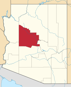
Cherry is a mining ghost town in central Yavapai County, Arizona, United States, between Dewey and Camp Verde, located at an elevation of 5143 feet.[1]
Cherry, Arizona | |
|---|---|
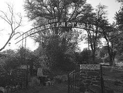 Cherry cemetery, 1886 | |
 Cherry, Arizona Location within the state of Arizona  Cherry, Arizona Cherry, Arizona (the United States) | |
| Coordinates: 34°35′17″N 112°02′31″W | |
| Country | United States |
| State | Arizona |
| County | Yavapai |
| Elevation | 5,143 ft (1,568 m) |
| Time zone | UTC-7 (Mountain (MST)) |
| Wikimedia Commons has media related to Cherry, Arizona. |
History
Cherry's post office was established March 3, 1884 and discontinued March 15, 1943. Notable mines in the area include the Federal, Bunker, Sunnybrook, Logan and Gold Bullion[2] mines. About 400 people lived and worked in Cherry during its prime. At present, Cherry is a small retirement and vacation-home community. A number of the original buildings are still in use. The Cherry cemetery has several graves from the late 19th and early 20th centuries.
gollark: Since it stops when it encounters the first thing with the maximum sum, I think?
gollark: Based on skimming it, your code already does that.
gollark: I don't see what the actual question/problem is.
gollark: I disagree. Some are obviously stupid. Some are less obviously or more subjectively stupid. Doesn't mean stupidity is constant.
gollark: Would you be happy if your documents randomly broke in updates?
References
- Cherry ghost town info
- "Gold Bullion Mine (Copper Bullion Mine), Cherry, Cherry Creek District, Black Hills (Black Hill Range), Yavapai Co., Arizona, USA". Mindat.org. 2010-07-30. Retrieved 2010-08-04.
External links
- Cherry ghost town, photos
- Cherry photo gallery
- Cherry USGS topographic map, at TopoQuest
- The Story of Cherry, Arizona on Cherry Fire website
This article is issued from Wikipedia. The text is licensed under Creative Commons - Attribution - Sharealike. Additional terms may apply for the media files.