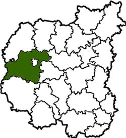
Chernihiv Raion
Chernihivskyi Raion (Ukrainian: Чернігівський район) is a raion (district) of Chernihiv Oblast, northern Ukraine. Its administrative centre is the city of Chernihiv, which is incorporated as a city of oblast significance and does not belong to the raion. The raion covers an area of 2,547 square kilometres (983 sq mi). Population: 51,902 (2019 est.)[1]
Chernihivskyi Raion Чернігівський район | |
|---|---|
Raion | |
 Flag  Coat of arms | |
 Raion location in Chernihiv Oblast | |
| Coordinates: 51°29′N 31°17′E | |
| Country | Ukraine |
| Oblast | Chernihiv Oblast |
| Admin. center | Chernihiv |
| Area | |
| • Total | 2,547 km2 (983 sq mi) |
| Elevation | 130 m (430 ft) |
| Population (2019) | |
| • Total | 51,902 |
| • Density | 20.8/km2 (54/sq mi) |
| Time zone | UTC+2 (EET) |
| • Summer (DST) | UTC+3 (EEST) |
| Website | Official website |
Geography
Overview
The raion borders with the raions of Ripky, Horodnia, Mena, Kulykivka and Kozelets. It borders also with the city of Slavutych, an exclave of Kiev Oblast, the Kievan raion of Ivankiv, and the Belarusian raion of Brahin, in Gomel Oblast. Its capital, Chernihiv, is located in the middle of the raion, but is administratively separate.[2]
gollark: [REDACTED] See ████ ██
gollark: ← see left
gollark: No comment.
gollark: True intellectuals guess the password to the account of someone using a reddit meme investment game, then run a bot on it to confuse them.
gollark: True intellectuals play Monopoly.
See also
References
- "Чисельність наявного населення України (Actual population of Ukraine)" (PDF) (in Ukrainian). State Statistics Service of Ukraine. Retrieved 23 May 2020.
- 1753464 Chernihiv Raion on OpenStreetMap
This article is issued from Wikipedia. The text is licensed under Creative Commons - Attribution - Sharealike. Additional terms may apply for the media files.