Chaunggyi
Chaunggyi, also known as Chaung Gyi and Chaung-gyi, is a village in Tha bake kyìn Township သပိတ္က်င္းၿမိဳ႕နယ္, Pyinoolwin District, Mandalay Division, Myanmar.[1]
Chaunggyi | |
|---|---|
Village | |
 Chaunggyi | |
| Coordinates: 22°43′N 96°1′E | |
| Country | |
| Division | Mandalay Division |
| District | Pyin Oo Lwin District |
| Township | Tha bake kyin Township |
| Elevation | 732 ft (223 m) |
| Time zone | UTC+6:30 (MMT) |
Geography
The Chaunggyi valley is located about 3,5 km northeast of Letha Taung, also known as the Singu Plateau, near National Highway 31.[2] In the valley there are Lisu (at Lezawchaunggyi), Palaung (at Palaungchaunggyi), Shan and Gurkha ethnic minorities living in separate villages.
gollark: Hmm, it doesn't take escaped emojis either.
gollark: =tex \🅱️
gollark: =tex \iota \sigma \xi \kappa \theta \chi \psi
gollark: =tex \alpha \beta \gamma \delta
gollark: Neat.
References
- Mindat - Chaung-gyi, Tha bake kyinTownship သပိတ္က်င္းျမ်ဳ႕နယ္, Pyin-Oo-Lwin District, Mandalay Division, Myanmar
- "Letha Taung". Mapcarta. Retrieved 1 June 2016.
Capital: Mogok | |
|
Capital: Mandalay | ||
| Kyaukse District |  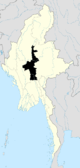 | |
| Mandalay District | ||
| Meiktila District | ||
| Myingyan District | ||
| Nyaung-U District |
| |
| Pyinoolwin District | ||
| Yamethin District | ||
| Main cities and towns | ||
This article is issued from Wikipedia. The text is licensed under Creative Commons - Attribution - Sharealike. Additional terms may apply for the media files.