Cha Ung
Cha Ung (Khmer: ចាអ៊ុង) is a commune in Ou Chum District in north-east Cambodia. It contains Char Ung Ket, Char Ung Chan, Phlay Ampil, Thuoy Tum, Char Ung Kao villages and has a population of 1,733.[1] In the 2007 commune council elections, all five seats went to members of the Cambodian People's Party.[2] The land alienation rate in Cha Ung was moderate as of January 2006.[3] (See Ratanakiri Province for background information on land alienation.)
Cha Ung ចាអ៊ុង | |
|---|---|
 Cha Ung Location within Cambodia | |
| Coordinates: 13°45′34″N 106°55′49″E | |
| Country | |
| Province | Ratanakiri |
| District | Ou Chum District |
| Villages | 5 |
| Population | |
| • Total | 1,733 |
| Time zone | UTC+07 |
| Geocode | 160601 |
Villages
| Village[1][4] | Population[1] (1998) | Sex ratio[1] (male/female) (1998) | Number of households[1] (1998) | Notes |
|---|---|---|---|---|
| Char Ung Ket | 177 | 42 | 0.90 | |
| Char Ung Chan | 354 | 80 | 0.92 | |
| Phlay Ampil | 556 | 131 | 0.99 | |
| Thuoy Tum | 208 | 60 | 0.79 | |
| Cha Ung Kau | 438 | 79 | 0.90 |
gollark: You still haven't had them factor any semiprimes for me.
gollark: Did you know? Carthage must be destroyed.
gollark: pls initiate contingency aleph
gollark: pls deploy infinite bees
gollark: Your model was correct.
References
- "Final Population Totals, Rotanak Kiri Province, 1998" (PDF). Cambodia National Institute of Statistics. Archived from the original (PDF) on October 29, 2008. Retrieved June 6, 2008.
- "Official Results of the 2007 Commune Councils Election in Ratank Kiri" (PDF). National Election Committee, No 4.58/07 NEC.SG.PIB. April 18, 2007. Archived from the original (PDF) on June 2, 2008. Retrieved June 6, 2008.
- "Land Alienation in Indigenous Minority Communities - Ratanakiri Province, Cambodia" (PDF). NGO Forum on Cambodia. August 2006. Archived from the original (PDF) on June 14, 2008. Retrieved June 6, 2008.
- "Ratanak Kiri Province". Cambodia National Institute of Statistics. Archived from the original on June 2, 2008. Retrieved June 6, 2008.
Capital city: Banlung | |||||||||||||||||||
| Landmarks | 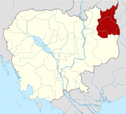 | ||||||||||||||||||
| Administrative divisions |
| ||||||||||||||||||
This article is issued from Wikipedia. The text is licensed under Creative Commons - Attribution - Sharealike. Additional terms may apply for the media files.