Chérigné
Chérigné is a commune in the Deux-Sèvres department in the Nouvelle-Aquitaine region in western France.
Chérigné | |
|---|---|
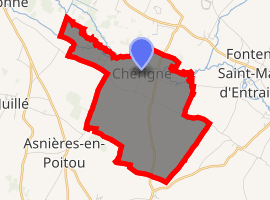
Location of Chérigné 
| |
 Chérigné  Chérigné | |
| Coordinates: 46°07′26″N 0°10′15″W | |
| Country | France |
| Region | Nouvelle-Aquitaine |
| Department | Deux-Sèvres |
| Arrondissement | Niort |
| Canton | Mignon-et-Boutonne |
| Intercommunality | Val de Boutonne |
| Government | |
| • Mayor (2008–2014) | Bernard Gaboreau |
| Area 1 | 7.88 km2 (3.04 sq mi) |
| Population (2017-01-01)[1] | 147 |
| • Density | 19/km2 (48/sq mi) |
| Time zone | UTC+01:00 (CET) |
| • Summer (DST) | UTC+02:00 (CEST) |
| INSEE/Postal code | 79085 /79170 |
| Elevation | 58–115 m (190–377 ft) (avg. 66 m or 217 ft) |
| 1 French Land Register data, which excludes lakes, ponds, glaciers > 1 km2 (0.386 sq mi or 247 acres) and river estuaries. | |
Geography
The commune is traversed by the river Boutonne.
gollark: I mean, if you want the code *now* for some reason, I'll give you it?
gollark: Yes, Lua exists and I could embed it somehow, but there are !!FUN!! challenges with that:- the API is kind of unsafe so the Rust wrappers are not great- I would also have to write a bunch of glue code to allow interacting with pages and whatever, which is especially hard as my code is asynchronous- I'd *also* have to work out a nice way to integrate scripting into the interfæce still.
gollark: No, I would build some highly accursed migration tool.
gollark: Also yes.
gollark: Yes.
References
- "Populations légales 2017". INSEE. Retrieved 6 January 2020.
| Wikimedia Commons has media related to Chérigné. |
This article is issued from Wikipedia. The text is licensed under Creative Commons - Attribution - Sharealike. Additional terms may apply for the media files.