Cavaglio-Spoccia
Cavaglio-Spoccia was a comune (municipality) in the Province of Verbano-Cusio-Ossola in the Italian region Piedmont, located about 140 kilometres (87 mi) northeast of Turin and about 20 kilometres (12 mi) northeast of Verbania, on the border with Switzerland. As of 31 December 2004, it had a population of 273 and an area of 18.2 square kilometres (7.0 sq mi).[3] The municipality consisted of the villages of Cavaglio, Gurrone, Lunecco and Spoccia.
Cavaglio-Spoccia | |
|---|---|
| Comune di Cavaglio-Spoccia | |
 Coat of arms | |
Location of Cavaglio-Spoccia 
| |
 Cavaglio-Spoccia Location of Cavaglio-Spoccia in Italy 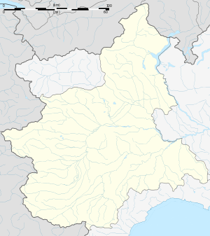 Cavaglio-Spoccia Cavaglio-Spoccia (Piedmont) | |
| Coordinates: 46°4′9″N 8°36′30″E | |
| Country | Italy |
| Region | Piedmont |
| Province | Province of Verbano-Cusio-Ossola (VB) |
| Frazioni | Cavaglio, Gurrone, Lunecco and Spoccia |
| Area | |
| • Total | 18.2 km2 (7.0 sq mi) |
| Elevation | 697 m (2,287 ft) |
| Population (Dec. 2004)[2] | |
| • Total | 273 |
| • Density | 15/km2 (39/sq mi) |
| Time zone | UTC+1 (CET) |
| • Summer (DST) | UTC+2 (CEST) |
| Postal code | 28052 |
| Dialing code | 0323 |
On 1 January 2019 the municipalities of Cursolo-Orasso, Cavaglio-Spoccia and Falmenta merged into the municipality of Valle Cannobina.[4]
Cavaglio-Spoccia bordered the following municipalities: Brissago (Switzerland), Cannobio, Cursolo-Orasso, Falmenta, Gurro, Palagnedra (Switzerland).
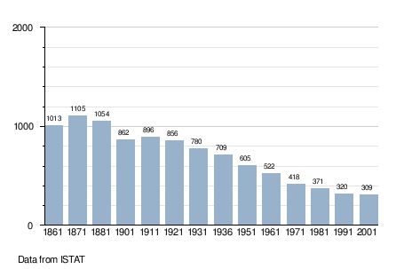
Demographic evolution
gollark: This is basically just "call code outside your process" in a slightly different way.
gollark: Clothier is Haskell?
gollark: Sockets allow you to distribute stuff across multiple machines.
gollark: IPC is processes on the same computer, generally.
gollark: The trendy™ thing now is microservices.
References
- "Superficie di Comuni Province e Regioni italiane al 9 ottobre 2011". Istat. Retrieved 16 March 2019.
- "Popolazione Residente al 1° Gennaio 2018". Istat. Retrieved 16 March 2019.
- All demographics and other statistics: Italian statistical institute Istat.
- "Valle Cannobina municipality" (PDF).
This article is issued from Wikipedia. The text is licensed under Creative Commons - Attribution - Sharealike. Additional terms may apply for the media files.