Carriers' Dock
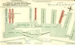
Carriers' Dock (or North Carriers' Dock) was a dock on the River Mersey, England, and part of the Port of Liverpool. The dock was situated in the northern dock system and connected to Brocklebank Dock to the west.
| Carriers' Dock | |
|---|---|
 British Empire Dockyards and Ports map of 1909, showing North Carriers' Dock as Carrier Dock. By 1909, South Carriers' Dock had been replaced by Brocklebank Graving Dock. | |
| Location | |
| Location | Bootle, Merseyside, United Kingdom |
| Coordinates | 53.4412°N 3.0031°W |
| OS grid | SJ333943 |
| Details | |
| Opened | 1862[1] |
| Closed | After September 1972[2] |
| Type | Wet dock |
| Joins | Brocklebank Dock (former) |
| Area | 2 acres (0.81 ha), 3,423 sq yd (2,862 m2)[1] |
| Width at entrance | 40 ft (12 m)[3] |
| Quay length | 641 yd (586 m)[1] |
History
The dock was originally the northern of a pair of docks joining Brocklebank Dock, known as North Carriers' Dock and South Carriers' Dock.[3] The docks were each 40 ft (12 m) wide at the entrance,[3] and were intended for use by river goods carriers.[4]
North Carriers' Dock was opened in 1862, with a basin covering 2 acres (0.81 ha), 3,423 sq yd (2,862 m2) and with a total quayside of 641 yd (586 m).[1] South Carriers' Dock had a basin covering 1 acre (0.40 ha), 4,515 sq yd (3,775 m2) and with a total quayside of 615 yd (562 m).[1]
The site of South Carriers' Dock was used for a graving dock in 1898.[4][5]
From 15 May 1968 until 30 September 1972, the northern quayside of Carriers' Dock was used as a temporary terminal for the B&I Line, prior to the company using Trafalgar Dock,[2][6] and for MD&HB cargo handling around the same time.[7] The southern quayside of Carriers' Dock was a rough cargo berth.[7]
North Carriers' Dock was filled in the late 20th century,[8] and the site has been redeveloped.
References
- Wilson c. 1866, p. 72
- Collard 2012
- Office of Naval Intelligence 1900, p. 294
- McCarron & Jarvis 1992, p. 15
- "Harbours and Inland Waterways in 1903" (PDF). The Engineer. XCVII. 1 January 1904. Retrieved 4 September 2016.
- Collard 2015
- Collard 2001, p. 109
- "Warehouse at 12 Effingham Street". Historic England. Retrieved 4 September 2016.
Sources
- Collard, Ian (2001). Mersey Ports: Liverpool & Birkenhead. Stroud: Tempus Publishing Ltd. ISBN 9780752421100. OCLC 223276957.CS1 maint: ref=harv (link)
- Collard, Ian (2012). Liverpool Docks Through Time. Amberley Publishing Ltd. ISBN 9781445604145. OCLC 866867097.CS1 maint: ref=harv (link)
- Collard, Ian (2015). Coast Lines: Fleet List and History. Amberley Publishing Ltd. ISBN 9781445646749. OCLC 951099407.CS1 maint: ref=harv (link)
- McCarron, Ken; Jarvis, Adrian (1992). Give a Dock a Good Name?. Birkenhead: Merseyside Port Folios. ISBN 9780951612941. OCLC 27770301.CS1 maint: ref=harv (link)
- Office of Naval Intelligence (1900). Coaling, docking, and repairing facilities of the ports of the world (4th ed.). Washington: Government Printing Office. OCLC 951099407.CS1 maint: ref=harv (link)
- Wilson, John Marius (c. 1866). The Imperial Gazetteer of England and Wales. Vol. IV. Leescourt—Mounton. Edinburgh: A. Fullarton & Co. OCLC 70391215.CS1 maint: ref=harv (link)
External links
- "Liverpool North Docks diagram". Liverpool 2007. Archived from the original on 30 March 2007.