Camapuã
Camapuã is a municipality located in the Brazilian state of Mato Grosso do Sul. Its population was 14,230 (2005) and its area is 10,758 km².[1]
Camapuã | |
|---|---|
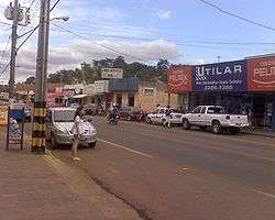 View of Camapuã | |
 Flag  Coat of arms | |
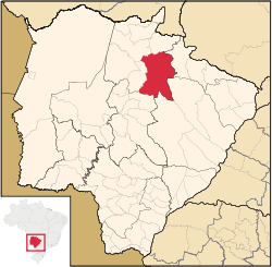 Location in Mato Grosso do Sul state | |
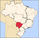
 Camapuã Location in Brazil | |
| Coordinates: 19°31′51″S 54°02′38″W | |
| Country | Brazil |
| Region | Central-West |
| State | Mato Grosso do Sul |
| Area | |
| • Total | 10,758 km2 (4,154 sq mi) |
| Elevation | 409 m (1,342 ft) |
| Population (2005) | |
| • Total | 14,230 |
| • Density | 1.3/km2 (3.4/sq mi) |
| Time zone | UTC-04:00 (BRT-1) |
| • Summer (DST) | UTC-03:00 (BRST-1) |
References
- IBGE - "Archived copy". Archived from the original on 2008-06-11. Retrieved 2008-06-11.CS1 maint: archived copy as title (link)
Capital: Campo Grande | |||||||||
| Mesoregion Centro Norte de Mato Grosso do Sul |
|  | |||||||
| Mesoregion Leste de Mato Grosso do Sul |
| ||||||||
| Mesoregion Pantanal Sul Mato-Grossense |
| ||||||||
| Mesoregion Sudoeste de Mato Grosso do Sul |
| ||||||||
This article is issued from Wikipedia. The text is licensed under Creative Commons - Attribution - Sharealike. Additional terms may apply for the media files.