Caldron Peak
Caldron Peak is a 2,911-metre (9,551 ft) mountain peak of the Waputik Range, located in Alberta, Canada.[1][2] It is prominently visible from the Peyto Lake Overlook in Banff National Park.
| Caldron Peak | |
|---|---|
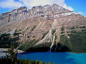 Caldron Peak and Peyto Lake | |
| Highest point | |
| Elevation | 2,911 m (9,551 ft) [1] |
| Prominence | 449 m (1,473 ft) [2][note 1] |
| Parent peak | Mistaya Mountain (3096 m)[2] |
| Listing | Mountains of Alberta |
| Coordinates | 51°43′08″N 116°32′42″W [3] |
| Geography | |
 Caldron Peak Location in Alberta  Caldron Peak Caldron Peak (Canada) | |
| Location | Banff National Park Alberta, Canada |
| Parent range | Waputik Range Canadian Rockies |
| Topo map | NTS 82N/10[3] |
| Climbing | |
| First ascent | 1948 FRA: C. Beattie and an ACC party |
It was named after Caldron Lake which is 3 km (1.9 mi) from its summit.
Geology
Like other mountains in Banff Park, Caldron Peak is composed of sedimentary rock laid down during the Precambrian to Jurassic periods.[4] Formed in shallow seas, this sedimentary rock was pushed east and over the top of younger rock during the Laramide orogeny.[5]
Climate
Based on the Köppen climate classification, Caldron Peak is located in a subarctic climate with cold, snowy winters, and mild summers.[6] Temperatures can drop below -20 C with wind chill factors below -30 C. Precipitation runoff from Caldron Peak Peak drains into the Mistaya River which is a tributary of the North Saskatchewan River.
References
- "Caldron Peak". PeakFinder.com. Retrieved 2019-08-11.
- "Caldron Peak". Bivouac.com. Retrieved 2019-08-26.
- "Caldron Peak". Geographical Names Data Base. Natural Resources Canada. Retrieved 2019-08-26.
-
Belyea, Helen (1960). "The Story of the Mountains in Banff National Park" (PDF). Geological Survey of Canada. Archived (PDF) from the original on 2 October 2015. Retrieved 2019-06-23. Cite journal requires
|journal=(help) - Gadd, Ben (2008). "Geology of the Rocky Mountains and Columbias". Cite journal requires
|journal=(help) - Peel, M. C.; Finlayson, B. L. & McMahon, T. A. (2007). "Updated world map of the Köppen−Geiger climate classification". Hydrol. Earth Syst. Sci. 11: 1633–1644. ISSN 1027-5606.
Footnotes
- Based on an elevation of 2909 m