Burdekin Bridge
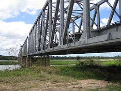
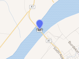
The Burdekin Bridge (known as the Burdekin River Bridge or Silver Link) spans the Burdekin River between the towns of Ayr and Home Hill, Queensland, Australia. Located on the Bruce Highway which is part of Highway 1, it is an important link in the national road network. It is a road-rail bridge which provides high flood immunity link between north and south Queensland.[1]
Burdekin Bridge | |
|---|---|
 Burdekin Bridge | |
| Coordinates | 19°38′26″S 147°23′41″E |
| Carries | Motor vehicles, Railway |
| Crosses | Burdekin River |
| Locale | between the towns of Ayr and Home Hill, Queensland, Australia |
| Other name(s) | Burdekin River Bridge or the Silver Link |
| Preceded by | Inkerman bridge |
| Characteristics | |
| Design | Truss bridge |
| Material | Steel |
| Total length |
|
| Longest span | 250 feet (76.2 m) |
| No. of spans | 10 main spans and 22 approach spans[2] |
| Piers in water | 9 |
| History | |
| Designer | Harry Lowe, Noel Ullman, Bill Hansen |
| Construction start | April 1947 |
| Construction end | 1957 |
| Opened | 27 March 1957[3][4][5] |
| Statistics | |
| Daily traffic | 7000 |
| Toll | No |
| |

The Bridge was completed in 1957. Construction began 10 years earlier in 1947.[6] At 3,620 feet (1,103 m) in length, it is one of the longest multi-span bridges in Australia and longer than Brisbane's Story Bridge or New South Wales's Hawkesbury River Railway Bridge. It is 46 metres shorter than Sydney's Harbour Bridge.[1][7]
History
Originally, it was thought that the bridge could not be built in its present location. No trace of rock could be found on which to build the bridge foundations. In 1946, two high-ranking Government engineers visited India to inspect a number of bridges built on sand foundations. The same technique was used for the Burdekin Bridge and it is the only bridge in Australia not built with a firm foothold.
The bridge rests on 11 huge, hollow, concrete caissons sunk into the river bed. The caissons are 17 metres across the top (measured parallel to the stream) and vary in width from 5.5 to 7.6 metres. The caissons were sunk into the river bed to a depth of about 30 metres. Add to that the approximately 20 metres that the caissons rise above the bed and the end result is some very massive pieces of concrete. Each weighs about 4,000 tons. The caissons were fitted with steel "cutting edges" to help them sink. The steel used in the cutting edges weighed 238 tons.
Construction of the first caisson started in 1947 after the "wet season". As each caisson rose in height, sand was removed from the centre of the caisson to make it sink into the sand bed. To get such a tremendous mass to sink gradually and evenly was difficult. To add to the difficulties, often a caisson became stuck and a diver had to be sent down to find the problem and remedy it. Another difficulty was that each caisson had to be sunk to a secure depth before the "wet season". If a caisson was not firmly anchored deep enough, a flood could have swept it away.
Because the bridge does not have rock foundations but is entirely supported by sand, it is sometimes described as a floating bridge. It is not a true floating bridge as it does not float on water.
The metal bridge spans were bolted together with high-tensile bolts instead of being riveted. At the time, no other Australian bridge had ever been constructed this way.
With all the difficulties, plus the shortage of steel after the Second World War, the construction took almost a decade to complete at a cost of $6 million. Despite these setbacks, the new bridge greatly assisted in travel between Ayr, Queensland and Home Hill, Queensland and formed a vital link between North and South Queensland.
The Silver Link replaced a bridge which is set just off the river bed. It was regularly covered and washed away by flood waters but it is still possible to see the remains of the old bridge when the river level is low.
Due to the special construction of the bridge, with steel beams forming a truss over the highway, it is regularly being closed to let pass oversize loads which take both lanes on the narrow bridge.
In October 2010 the Burdekin Bridge was recognised as a National Engineering Heritage Landmark.[5]
A 5-year bridge maintenance and rehabilitation project had commenced in 2013. It is the first major structural rehabilitation work undertaken since the bridge construction.[1]
Inkerman bridge | |
|---|---|
| Coordinates | 19°38′24″S 147°23′40″E |
| Crosses | Burdekin River |
| Locale | Ayr |
| Characteristics | |
| Total length | 830 yd 1 ft (37.7 chains; 759.3 m) |
| No. of spans | 129[8] |
| History | |
| Construction start | 1912[9] |
| Construction end | 1913 |
| Construction cost | £18,000 |
| Opened | Sept 1913 |
|
| |
Engineering heritage
The bridge was listed as an Engineering Heritage National Landmark by Engineers Australia as part of its Engineering Heritage Recognition Program.[10]
See also
- List of road-rail bridges
References
- "Burdekin River Bridge: maintenance and rehabilitation project". Department of Transport and Main Roads, Queensland. Retrieved 19 October 2010.
- "BIG UNDERTAKING". The Proserpine Guardian. 42 (2837). Queensland, Australia. 14 February 1947. p. 1 – via National Library of Australia.
- "News and Notes From the N.R.M.A." The St. George Call. 53 (16). New South Wales, Australia. 18 April 1957. p. 6 – via National Library of Australia.
- "Burdekin Bridge". Burdekin Shire Council.
- Wensley, Penelope (5 October 2010). "Engineering Heritage National Landmark Award to the Burdekin River Bridge". Government House, Queensland. Archived from the original on 27 February 2014. Retrieved 7 September 2015.
- "BURDEKIN BRIDGE". Bowen Independent. 44 (4211). Queensland, Australia. 4 April 1947. p. 4 – via National Library of Australia.
- "Burdekin River Bridge maintenance" (PDF). Main Roads. Archived from the original (PDF) on 10 March 2016. Retrieved 15 October 2017.
- "THE LINKING UP OF THE LINES". Bowen Independent. 10 (583). Queensland, Australia. 9 August 1913. p. 2 – via National Library of Australia.
- "The North Coast Railway". Gympie Times and Mary River Mining Gazette. XLVI (7114). Queensland, Australia. 21 August 1913. p. 1 – via National Library of Australia.
- "Burdekin River Bridge, Bruce Highway, 1947-". Engineers Australia. Retrieved 27 April 2020.
Further reading
- High-level combined rail and road bridge over Burdekin River between Ayr and Home Hill, Government Printer, 1955
- Scott, Laura A; Lower Burdekin Historical Society (2007), Bridging the gap : celebrating the 50th anniversary of the Burdekin River bridge, Lower Burdekin Historical Society Inc
External links
| Wikimedia Commons has media related to Burdekin Bridge. |
- "Burdekin Bridge known as the "Silver Link"". Burdekin Shire Council. Retrieved 7 September 2015.