Broad Fourteens
The Broad Fourteens is an area of the southern North Sea that is fairly consistently fourteen fathoms (84 feet/26 metres) deep. Thus, on a nautical chart with depths given in fathoms, a broad area with many "14" notations can be seen.
Extent
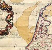
The Broad Fourteens region is located off the coast of the Netherlands and south of the Dogger Bank, roughly between longitude 3°E and 4°30'E and latitude 52°30'N and 53°30'N.
The area is known to the Dutch and German navies as the Breeveertien.
Geologically it is comparable to the Long Forties, another submerged plateau that has related origins.
Naval battles
The area has been the scene of many naval engagements throughout history. For example:
- The torpedoing of three British cruisers in the Action of 22 September 1914[1]
Navigation
The shallowness of this area means that the largest oil tankers when fully loaded cannot traverse the Broad Fourteens to reach the English Channel from the North Sea because their draft is too deep.[2]
See also
- Dogger Bank for map and links to similar places
References
- Corbett, J S (1938). Naval Operations (2nd repr. Imperial War Museum and Naval & Military Press ed.). London: Longmans, Green. pp. 172–173. ISBN 1-84342-489-4. Retrieved 17 October 2018.
- Singh, Baljit (July 11, 1999). "The world's biggest ship". The Times of India. Tribune India. Retrieved 2020-05-09.