Bragança, Pará
Bragança, Pará is a municipality in the state of Pará in the Northern region of Brazil.[3][4][5][6]
Bragança, Pará | |
|---|---|
Municipality | |
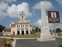 Bragança (Sao Pedro Alcantara) Cathedral and Obelisk | |
.svg.png) Flag  Seal | |
| Nickname(s): Tera da Marujada (Land of the Fandango) | |
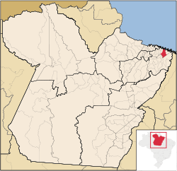 Location of Bragança in the State of Pará | |
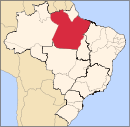
 Bragança, Pará Location in Brazil | |
| Coordinates: 01°03′46″S 46°46′22″W | |
| Country | |
| Region | Northern |
| State | Pará |
| Mesoregion | Nordeste Paraense |
| Demonym | bragantino(a) |
| Founded | 1613 |
| Government | |
| • Mayor | Joao Nelson Pereira Magalhaes (PT) |
| Area | |
| • Total | 810.098 sq mi (2,098.144 km2) |
| Elevation | 62 ft (19 m) |
| Population (2018 est.[2]) | |
| • Total | 126,436 |
| • Density | 160/sq mi (60/km2) |
| Time zone | UTC -3 |
The municipality contains part of the 27,864 hectares (68,850 acres) Tracuateua Marine Extractive Reserve, a sustainable use conservation unit created in 2005.[7] It contains the 42,069 hectares (103,950 acres) Caeté-Taperaçu Marine Extractive Reserve, created in 2005.[8]
History
The city was founded as New Bragança (after Bragança, Portugal).
gollark: I have an old tower server which costs maybe £5/month to run, which provides ~4x the CPU/RAM and ~10x the disk I'd get from a cloud provider at similar pricing, plus I could install a spare GPU when I wanted that. This is a very extreme case since I am entirely ignoring my time costs on managing it and don't have as much redundancy as them.(Edit: also terrible internet connectivity, and colocation would be expensive)
gollark: Possibly also that you can hire fewer sysadmins? But I'm not sure they're that expensive if you have a lot of developers anyway.
gollark: I think the argument for cloud is mostly that it's much faster to scale than "have a bunch of servers in your office", but it seems like you pay an insane amount for that.
gollark: Most of them have tons of managed services plus quick to deploy VMs.
gollark: Depending on how you define cloud, I guess.
See also
References
- "Brazilian Institute of Geography and Statistics" (in Portuguese). 2017. Retrieved 27 March 2019.
2018 Area Total
- "Brazilian Institute of Geography and Statistics" (PDF) (in Portuguese). 2018. Retrieved 6 March 2019.
2018 Estimates of Population
- "Divisão Territorial do Brasil" (in Portuguese). Divisão Territorial do Brasil e Limites Territoriais, Instituto Brasileiro de Geografia e Estatística (IBGE). July 1, 2008. Retrieved December 17, 2009.
- "Estimativas da população para 1º de julho de 2009" (PDF) (in Portuguese). Estimativas de População, Instituto Brasileiro de Geografia e Estatística (IBGE). August 14, 2009. Retrieved December 17, 2009.
- "Ranking decrescente do IDH-M dos municípios do Brasil" (in Portuguese). Atlas do Desenvolvimento Humano, Programa das Nações Unidas para o Desenvolvimento (PNUD). 2000. Archived from the original on October 3, 2009. Retrieved December 17, 2009.
- "Produto Interno Bruto dos Municípios 2002-2005" (PDF) (in Portuguese). Instituto Brasileiro de Geografia e Estatística (IBGE). December 19, 2007. Archived from the original (PDF) on October 2, 2008. Retrieved December 17, 2009.
- RESEX Marinha de Tracuateua (in Portuguese), ISA: Instituto Socioambiental, retrieved 2016-06-04
- RESEX Marinha de Caeté-Taperaçu (in Portuguese), ISA: Instituto Socioambiental, retrieved 2016-09-12
Capital: Belém | |||||||||||||||
| Mesoregion Lower Amazonas |
|  | |||||||||||||
| Mesoregion Marajó |
| ||||||||||||||
| Mesoregion Metropolitan Belém |
| ||||||||||||||
| Mesoregion Northeastern Pará |
| ||||||||||||||
| Mesoregion Southeastern Pará |
| ||||||||||||||
| Mesoregion Southwestern Pará |
| ||||||||||||||
This article is issued from Wikipedia. The text is licensed under Creative Commons - Attribution - Sharealike. Additional terms may apply for the media files.