Melgaço, Pará
Melgaço is a Brazilian municipality in the state of Pará. It stands at an altitude of 12 meters. Its population was estimated in 2005 at 25,153 inhabitants, according to the IBGE.
Melgaço | |
|---|---|
Municipality | |
 Flag | |
 | |
 Melgaço | |
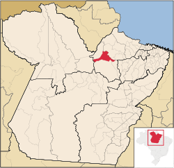
| Coordinates: 01°48′14″S 50°42′43″W | |
| Country | Brazil |
| State | Pará |
| Mesoregion | Marajó [1] |
| Microregion | Portel [1] |
| Government | |
| • Mayor | Jose Maria Rodrigues Viegas (PSDB) |
| Area | |
| • Total | 6,773.975 km2 (2,615.446 sq mi) |
| Elevation | 12 m (39 ft) |
| Population | |
| • Total | 17,989 |
| • Density | 2.7/km2 (6.9/sq mi) |
| Time zone | -3 |
| HDI | 0.525[3] |
| GDP | R$ 37,559,000[4] |
| GDP per capita | R$1.493,00 |
It is located 290 km, in a straight line, from the capital of the state. It borders Portel, Breves, Bagre, Gurupá and Porto de Moz.
The hymn and seal of the municipality were composed by Francisco de Oliveira e Souza.
The Estação Científica Ferreira Pena (Ferreira Pena Science Station) is located in the rural area of Melgaço, on a river named Curuá, a tributary of the Caxiuanã.
References
- "Divisão Territorial do Brasil". Divisão Territorial do Brasil e Limites Territoriais. Instituto Brasileiro de Geografia e Estatística (IBGE). 1 July 2008. Archived from the original on 14 June 2020. Retrieved 11 October 2008.
- "Estimativas da população para 1º de julho de 2008" (PDF). Instituto Brasileiro de Geografia e Estatística (IBGE). 29 August 2008. Retrieved 5 September 2008.
- "Ranking decrescente do IDH-M dos municípios do Brasil". Atlas do Desenvolvimento Humano. Programa das Nações Unidas para o Desenvolvimento (PNUD). 2000. Archived from the original on 3 October 2009. Retrieved 11 October 2008.
- "Produto Interno Bruto dos Municípios 2002-2005" (PDF). Instituto Brasileiro de Geografia e Estatística (IBGE). 19 December 2007. Archived from the original (PDF) on 2 October 2008. Retrieved 11 October 2008.
This article is issued from Wikipedia. The text is licensed under Creative Commons - Attribution - Sharealike. Additional terms may apply for the media files.