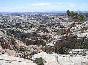
Box-Death Hollow Wilderness
Box-Death Hollow Wilderness is a 25,751 acres (104 km2) wilderness area located in south-central Utah, United States, on the Dixie National Forest. Vertical gray-orange walls of Navajo sandstone stand above two canyon tributaries of the Escalante River in Box-Death Hollow. The name Death Hollow gives reference to a number of livestock that plunged to their death trying to cross the steep canyon.
| Box-Death Hollow Wilderness | |
|---|---|
IUCN category Ib (wilderness area) | |
 Box-Death Hollow Wilderness | |
 | |
| Location | Garfield County, Utah, U.S. |
| Nearest city | Escalante, Utah |
| Coordinates | 37°53′30″N 111°38′03″W[1] |
| Established | September 18, 1984 |
| Governing body | U.S. Forest Service |
Running north-south through a steeply dipping monocline, Pine Creek forms the box canyon (a canyon accessible only at the lower end) known appropriately as "The Box." Death Hollow Creek, east of The Box, has carved its way through a gently dipping monocline. Raging waters often flood these canyon narrows after a rain. Pinyon and juniper cover many of the plateaus above the canyons. Brown and rainbow trout are plentiful in Pine Creek and in portions of Sand Creek. Along the creek banks, you may see mule deer, an occasional cougar, or even elk in winter. Three bird species listed by the Utah Division of Wildlife Resources as "sensitive" can be found in the wilderness - Lewis's woodpecker, the western bluebird, and the mountain bluebird. Nine miles of trail run the distance of "the Box", while hiking in the remainder of this wilderness requires following drainages or undesignated routes.
The larger Phipps-Death Hollow Outstanding Natural Area, a Bureau of Land Management wilderness study area, is adjacent to the wilderness on the south. Phipps-Death Hollow is part of the Grand Staircase–Escalante National Monument.
The Box-Death Hollow Wilderness briefly became the center of controversy during debate over the Utah Wilderness Act of 1984 due to a company that was interested in drilling exploration wells for carbon dioxide. The ridge-top well sites and routes leading to them were cherry-stemmed out of the north side of the legislated boundary, but the project never went into production.
 Death Hollow
 Box-Death Hollow Wilderness
 Death Hollow
See also
- Dixie National Forest
- Wilderness
- National Wilderness Preservation System
- List of U.S. Wilderness Areas
- Wilderness Act
References
- "Box-Death Hollow Wilderness". The National Wilderness Preservation System. Wilderness.net. Retrieved 2008-11-28.
- Howard, Lynna P. (2005). Utah's Wilderness Areas: The Complete Guide. Westcliffe Publishers. ISBN 1-56579-388-9.
- Cunningham, Bill; Polly Burke (1998). Wild Utah: A Guide to 45 Roadless Recreation Areas. Falcon Publishing. ISBN 1-56044-616-1.
- "Box-Death Hollow Wilderness". Parks. GORP. Archived from the original on 2010-05-13. Retrieved 2008-11-28.
External links
- "Dixie National Forest". US Forest Service. Retrieved 2008-11-28.