Bowesmont, North Dakota
Bowesmont is an unincorporated community in Pembina County, North Dakota, United States. Bowesmont is located along a BNSF Railroad line near Interstate 29, 8.2 miles (13.2 km) north of Drayton.[2] The community was initially named Alma for Alma, Ontario in 1878; the name was changed to Bowesmont, for William Bowes, the town's first shopkeeper, six months later.[1] According to legend, Bowes won the right to name the town in a card game.[3]
Bowesmont, North Dakota | |
|---|---|
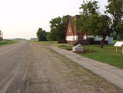 A church in Bowesmont | |
 Bowesmont, North Dakota  Bowesmont, North Dakota | |
| Coordinates: 48°41′24″N 97°10′41″W | |
| Country | United States |
| State | North Dakota |
| County | Pembina |
| Elevation | 794 ft (242 m) |
| Time zone | UTC-6 (Central (CST)) |
| • Summer (DST) | UTC-5 (CDT) |
| Area code(s) | 701 |
| GNIS feature ID | 1028097[1] |
Bowesmont was devastated by flooding of the Red River in 1997. Only an old church is left in what is now a ghost town.[4] An annual pilgrimage occurs the second Sunday of July where old friends, family and neighbors meet in the old church to celebrate what was the town they loved.[5]
Notable residents
- Harold Keith Johnson, Chief of Staff of the United States Army from 1964 to 1968[6]
gollark: Yes I can. I can program in ALL languages.
gollark: Yep!
gollark: Suffer?
gollark: Submit a full bug report with preprocessed source if appropriate?
gollark: Also Palaiologos account name reveal.
References
- "Bowesmont". Geographic Names Information System. United States Geological Survey.
- Pembina County (PDF) (Map). North Dakota Department of Transportation. 2006. Archived from the original (PDF) on October 2, 2006. Retrieved March 14, 2012.
- Federal Writers' Project workers (1938). North Dakota: A Guide to the Northern Prairie State. Works Progress Administration. p. 352.
- http://=www.ghostsofnorthdakota.com/2009/12/01/bowesmont-church%5B%5D
- https://www.fema.gov/pdf/about/regions/regionviii/jurnys32.pdf
- Capace, Nancy (2001). Encyclopedia of North Dakota. Somerset Publishers. p. 411.
External links
Municipalities and communities of Pembina County, North Dakota, United States | ||
|---|---|---|
| Cities | 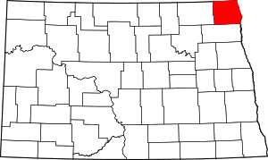 Map of North Dakota highlighting Pembina County | |
| Townships | ||
| Unincorporated communities | ||
This article is issued from Wikipedia. The text is licensed under Creative Commons - Attribution - Sharealike. Additional terms may apply for the media files.