Boumagueur
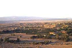
Boumagueur (Arabic: بومقر, Berber: ⴱⵓⵎⴰⴳⴻⵔ) is a town in northeast of Algeria. Area of the town is 111.69 km2, 8474 people live there, density of population is 76/km2.
Boumagueur | |
|---|---|
Town | |
 | |
 | |
| Coordinates: 35°30′19″N 5°33′9″E | |
| Country | Algeria |
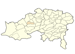
| Province | Batna |
| Area | |
| • Total | 111.69 km2 (43.12 sq mi) |
| Elevation | 756 m (2,480 ft) |
| Population | |
| • Total | 8,474 |
| • Density | 76/km2 (200/sq mi) |
| Time zone | UTC+1 (WAT) |
The climate prevailing in this region is very dry and hot, summer extends up to six months, there is cold and rainy winter, which range from 15 days to 20 days.
Localities of the town
The town of Boumagueur consists of 11 localities.:[1]
- Hassoune, capital of the town.
- Ouled Bouradi.
- Chantout (College).
- Al Feidh (Ouled Sahraoui).
- Sihcine.
- Al Khoualed.
- Megounssa (south).
- Lahnanchia.
- Al Keidh.
- Lahrakta.
- Al Bourat.
- bouraguba.
- el-ghar.
Borders
- East: Ouled Aouf, Ouled Si Slimane.
- West: Djezzar, Barika.
- North: N'Gaous, Gosbat.
- South: Sefiane.
Languages
All of the inhabitants can speak Shawia.
.svg.png)
gollark: Oh, I see.
gollark: A random nearby tree? The goblin? uqb?
gollark: GTech™ internet interruption drones, Mk 4.
gollark: BEE YUO
gollark: Upon whom?
This article is issued from Wikipedia. The text is licensed under Creative Commons - Attribution - Sharealike. Additional terms may apply for the media files.