Borders Abbeys Way
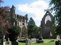
The Borders Abbeys Way is a long-distance footpath in the Scottish Borders area of Scotland. It is a circular walkway and is 109 kilometres (68 mi) in length.[1] The theme of the footpath is the ruined Borders abbeys (established by David I of Scotland) along its way: Kelso Abbey, Jedburgh Abbey, Melrose Abbey and Dryburgh Abbey. These abbeys were homes to monks, who lived there between the 12th and 16th centuries. The route also passes through the towns of Hawick and Selkirk, and close to Abbotsford House, the home of Sir Walter Scott.[2][3] Along the Borders Abbeys Way there are several rivers: Jed Water, River Teviot, River Tweed, Ale Water, and Rule Water.
| Borders Abbeys Way | |
|---|---|
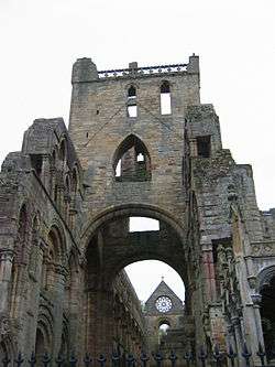 Jedburgh Abbey | |
| Length | 109 km (68 mi)[1] |
| Location | Borders, Scotland |
| Established | 2006 |
| Designation | Scotland's Great Trails |
| Trailheads | Circular |
| Use | Hiking |
| Elevation | |
| Elevation gain/loss | 1,300 metres (4,300 ft) gain[1] |
| Highest point | 339 metres (1,113 ft) |
| Hiking details | |
| Season | All year |
| Sights | Historic ruined abbeys, rivers, wildlife, countryside |
| Website | http://www.bordersabbeysway.com/ |
The route was opened in 2006, and is managed and maintained by Scottish Borders Council.[2] It is now designated as one of Scotland's Great Trails by Scottish Natural Heritage.[1] The route links with four of the other Great Trails: the Cross Borders Drove Road, the Romans and Reivers Route, St Cuthbert's Way and the·Southern Upland Way.[3] About 15,000 people use the path every year, of whom over 2,000 complete the entire route.[4]
Two walkers, Jack Low and Garry Cossar, became the first to complete the full trail in under 24 hours in June 2017. The feat was reported in the Southern Reporter, Border Telegraph and Hawick News.
Sections of the Walk
Most people choose to do the walk in one day for each segment.[5]
| Start | Finish | Distance | Start elevation | Finish elevation | Highest point | ||||
|---|---|---|---|---|---|---|---|---|---|
| km | mi | m | ft | m | ft | m | ft | ||
| Kelso (55.5970°N 2.4327°W) | Jedburgh | 19 | 12 | 41 | 134 | 85 | 280 | 120 | 390 |
| Jedburgh (55.4766°N 2.5541°W) | Hawick | 20 | 12 | 85 | 280 | 105 | 344 | 300 | 985 |
| Hawick (55.4285°N 2.7833°W) | Selkirk | 20 | 12 | 102 | 334 | 172 | 564 | 339 | 1,113 |
| Selkirk(55.5471°N 2.8415°W) | Melrose | 16 | 9.9 | 172 | 564 | 98 | 320 | 270 | 880 |
| Melrose(55.5990°N 2.7191°W) | Kelso | 28 | 17 | 98 | 320 | 41 | 134 | 148 | 485 |
| Complete walk | 103 | 64 | 339 | 1,113 | |||||
See also
- Pennine Way National Trail
- James Hutton Trail
- Roman Heritage Way
- Sir Walter Scott Way
References
- "Trails Archive". Scottish Natural Heritage & Rucksack Reader. Retrieved 15 August 2018.
- "Borders Abbeys Way" (PDF). Scottish Borders Council. 2018. Retrieved 15 August 2018.
- "Borders Abbeys Way". Scottish Natural Heritage & Rucksack Reader. Retrieved 15 August 2018.
- "Scotland's networks of paths and trails: key research findings" (PDF). Scottish Natural Heritage. August 2018. p. 6. Retrieved 26 September 2018.
- "Abbeys Walk". The Borders Abbeys Way. Scotland's Great Trails.
External links
| Wikimedia Commons has media related to Borders Abbeys Way. |
- Borders Abbeys Way Website
- Borders Abbeys Way pages on the Scottish Borders Council website
- Borders Abbeys Way route description and map (Walkhighlands).
- Visit Scotland: Walking the Borders Abbeys Way
- The Long Distance Walkers Association: Borders Abbeys Way
- Walking Magazine: "Borders of History"
- Britain: "Break for the Borders" Also mention of the Tironsian Abbey in Selkirk