Booval, Queensland
Booval is a suburb of Ipswich in the City of Ipswich, Queensland, Australia.[2] At the 2016 Australian Census the suburb recorded a population of 2,622.[1]
| Booval Ipswich, Queensland | |||||||||||||||
|---|---|---|---|---|---|---|---|---|---|---|---|---|---|---|---|
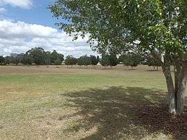
 Cameron Park, 2015 | |||||||||||||||
 Booval | |||||||||||||||
| Coordinates | 27°36′51.69″S 152°47′19.90″E | ||||||||||||||
| Population | 2,622 (2016)[1] | ||||||||||||||
| Postcode(s) | 4304 | ||||||||||||||
| Location | |||||||||||||||
| LGA(s) | City of Ipswich | ||||||||||||||
| State electorate(s) | Ipswich | ||||||||||||||
| Federal Division(s) | Blair | ||||||||||||||
| |||||||||||||||
The settlement of Booval derived from a private estate and its strategic location on the road and railway between Ipswich and Brisbane.[3]
Geography
Booval contains both residential and commercial areas.
Booval straddles Brisbane Road, the main arterial link to the Ipswich Motorway. The Booval Fair shopping centre, located on Brisbane Road, contains a number of major chain stores, including Woolworths and Big W, while a number of smaller businesses line South Station Rd and Brisbane Rd.
History
The origin of the suburb name is from the Kabi Aboriginal dialect meaning frilled lizard.[2]
The first large-scale cotton crops in Queensland were grown at Booval in the 1860s.[4]
By the time of 1915, Booval was occupied largely by miners, many of which had Welsh origins.[5]
Heritage listings

Booval has a number of heritage-listed sites, including:
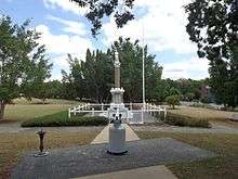
- Green Street: Booval War Memorial[6]
- 14 Cothill Road: Booval House[7]
Transport
Booval railway station provides access to regular Queensland Rail City network services to Brisbane, Ipswich and Rosewood via Ipswich.
Education
- Sacred Heart Catholic School
Amenities
The Ipswich City Council operates a fortnightly mobile library service which visits Cole Street.[8]
Parks and sports facilities
- Cameron Park
- Basketball Ipswich
- Booval Bowls Club
The Booval Swifts rugby league football club bears the suburb's name. During the 1920s, two of Booval's players, Dan Dempsey and Arthur Henderson were selected to represent Australia. The club has also produced other such notable players as Des Morris and Kevin Walters.
Places of worship
- Sacred Heart Catholic Church, Cothill Rd
- Uniting Church, Glebe Rd
- Anglican Church, Brisbane Rd
References
- Australian Bureau of Statistics (27 June 2017). "Booval (State Suburb)". 2016 Census QuickStats. Retrieved 25 March 2018.

- "Booval (entry 41866)". Queensland Place Names. Queensland Government. Retrieved 21 June 2017.
- "Suburbs and Place Names". Retrieved 20 April 2018.
- Beryl Johnston (29 March 2015). "Cotton an important crop in early Ipswich". Queensland Times. Retrieved 8 February 2016.
- Council, Ipswich City. "Suburb and Place Names". www.ipswich.qld.gov.au. Retrieved 20 September 2017.
- "Booval War Memorial (entry 600550)". Queensland Heritage Register. Queensland Heritage Council. Retrieved 9 July 2013.
- "Booval House (entry 600549)". Queensland Heritage Register. Queensland Heritage Council. Retrieved 9 July 2013.
- "Ipswich Libraries: Mobile library schedule of stops - January to June 2018" (PDF). Ipswich City Council. Archived from the original (PDF) on 30 January 2018. Retrieved 30 January 2018.
External links
| Wikimedia Commons has media related to Booval, Queensland. |