Bobi, Uganda
Bobi | |
|---|---|
 Bobi Location in Uganda | |
| Coordinates: 02°33′16″N 32°21′28″E | |
| Country | |
| Region | Northern Uganda |
| Sub-region | Acholi sub-region |
| District | Gulu District |
| Elevation | 3,000 ft (900 m) |
Bobi is a town in the Northern Region of Uganda.
Location
Bobi is in Gulu District along the Kamdini–Gulu Road, approximately 27 kilometres (17 mi), by road, south of Gulu, the largest city in the Northern Region.[1] The coordinates of the town are 2°33'16.0"N, 32°21'28.0"E (Latitude:2.554441; Longitude:32.357782).[2]
Points of interest
The following points of interest lie within the town limits or close to the edges of the town:
- offices of Bobi urban council
- Bobi central market
- Kamdini–Gulu Road, passing through the middle of town.
gollark: We could harvest communism to run our reactors.
gollark: Interesting.
gollark: It might truncate it. I had some issues when I accidentally put 17 outputs.
gollark: DALL-E Mini. Actual DALL-E is proprietary and OpenAIous.
gollark: (Stochastic Polynomial Unicode-Aware Multicharacter Automatic Indentation)
References
- GFC (3 January 2016). "Road Distance Between Gulu And Bobi With Map". Globefeed.com (GFC). Retrieved 3 January 2016.
- Google (3 January 2016). "Location of Bobi, Uganda At Google Maps" (Map). Google Maps. Google. Retrieved 3 January 2016.
Capital: Gulu | ||
| Towns and villages | 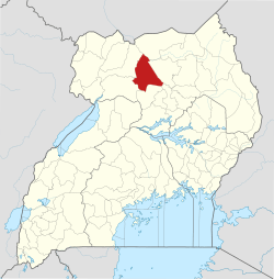 | |
| Banking | ||
| Hotels | ||
| Health |
| |
| Notable landmarks |
| |
| Transport |
| |
| Energy |
| |
| Education | ||
| Notable people | ||
This article is issued from Wikipedia. The text is licensed under Creative Commons - Attribution - Sharealike. Additional terms may apply for the media files.