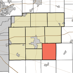
Blue River Township, Hancock County, Indiana
Blue River Township is one of nine townships in Hancock County, Indiana, United States. As of the 2010 census, its population was 1,417 and it contained 542 housing units.[1]
Blue River Township | |
|---|---|
 Location in Hancock County | |
| Coordinates: 39°44′41″N 85°40′41″W | |
| Country | United States |
| State | Indiana |
| County | Hancock |
| Government | |
| • Type | Indiana township |
| Area | |
| • Total | 29.83 sq mi (77.3 km2) |
| • Land | 29.75 sq mi (77.1 km2) |
| • Water | 0.08 sq mi (0.2 km2) 0.27% |
| Elevation | 909 ft (277 m) |
| Population (2010) | |
| • Total | 1,417 |
| • Density | 47.6/sq mi (18.4/km2) |
| GNIS feature ID | 0453117 |
History
Blue River was organized in 1828.[2] It was named from the Blue River, once an important waterway for mills.[3]
County Line Bridge was listed on the National Register of Historic Places in 1994.[4]
Geography
According to the 2010 census, the township has a total area of 29.83 square miles (77.3 km2), of which 29.75 square miles (77.1 km2) (or 99.73%) is land and 0.08 square miles (0.21 km2) (or 0.27%) is water.[1] The streams of Dilly Creek and Nameless Creek run through this township.
Adjacent townships
- Jackson Township (north)
- Ripley Township, Rush County (east)
- Hanover Township, Shelby County (south)
- Brandywine Township (west)
- Center Township (northwest)
Cemeteries
The township contains three cemeteries: Gilboa, Haskett, and Westland Friends Church.
gollark: <@236628809158230018> It would be expensive, but would *work*.
gollark: Probably? If you can't find one, you can make lava from RF easily.
gollark: My messages are going through out of order due to e-web issues, sorry.
gollark: Or listen for char and key events.
gollark: You can use `read` (same thing).
References
- Notes
- "Population, Housing Units, Area, and Density: 2010 - County -- County Subdivision and Place -- 2010 Census Summary File 1". United States Census. Archived from the original on 2020-02-12. Retrieved 2013-05-10.
- Richman, George J. (1916). History of Hancock County, Indiana: Its People, Industries and Institutions. Wm. Mitchell Printing Company. pp. 490.
- Binford, John H. (1882). History of Hancock County, Indiana: From Its Earliest Settlement by the "pale Face," in 1818, Down to 1882. King & Binford. pp. 49–50.
- "National Register Information System". National Register of Historic Places. National Park Service. July 9, 2010.
- Sources
This article is issued from Wikipedia. The text is licensed under Creative Commons - Attribution - Sharealike. Additional terms may apply for the media files.