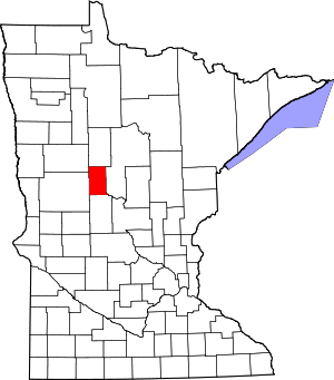
Blue Grass, Minnesota
Blue Grass is an unincorporated community in Wadena County, Minnesota, United States.[1][2]
Blue Grass | |
|---|---|
 Blue Grass  Blue Grass | |
| Coordinates: 46°32′34″N 95°00′36″W | |
| Country | United States |
| State | Minnesota |
| County | Wadena |
| Elevation | 1,355 ft (413 m) |
| Time zone | UTC-6 (Central (CST)) |
| • Summer (DST) | UTC-5 (CDT) |
| Area code(s) | 218 |
| GNIS feature ID | 640286[1] |
Notes
- "Blue Grass". Geographic Names Information System. United States Geological Survey.
- General Highway Map: Wadena County, Minnesota (PDF) (Map). Minnesota Department of Transportation. 2015. Retrieved March 5, 2017.
gollark: ?coliru```c#define A2(x, ...) x(x(__VA_ARGS__))#define R2(x) x x#define R4(x) A2(R2, x)#define R16(x) R4(R4(x))#define QUITELONG R16(long)int main(){QUITELONG x = 0;return 42;}```
gollark: ?coliru```c#define A2(x, y) x(x(y))#define R2(x) x x#define R4(x) A2(R2, x)#define R16(x) R4(R4(x))#define QUITELONG R16(long)int main(){QUITELONG x = 0;return 42;}```
gollark: Test.
gollark: ?coliru```c#define R2(x) x x#define R4(x) R2(R2(x))#define R16(x) R4(R4(x))#define QUITELONG R16(long)int main(){QUITELONG x = 0;return 42;}```
gollark: I think you can at least poke around with numbers.
This article is issued from Wikipedia. The text is licensed under Creative Commons - Attribution - Sharealike. Additional terms may apply for the media files.
