Bearii, Victoria
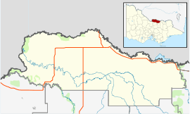
Bearii (/ˈbɪəraɪ/ BEER-eye) is a small settlement in Victoria, Australia.[4][5] The town is in the Shire of Moira local government area. Bearii is located 252 kilometres (157 mi) north of the state capital, Melbourne, 18 kilometres (11 mi) north of Waaia and is just south of the Barmah National Park.[6][7][8][9][10] At the 2011 census, Bearii had a population of 136,[1][11] by 2016 the town had 145 citizens.
| Bearii Victoria | |||||||||||||||
|---|---|---|---|---|---|---|---|---|---|---|---|---|---|---|---|
Former shop at Bearii | |||||||||||||||
 Bearii | |||||||||||||||
| Coordinates | 35°54′S 145°20′E | ||||||||||||||
| Population | 145 (2016 census)[1] | ||||||||||||||
| Established | c. 1875[2][3] | ||||||||||||||
| Postcode(s) | 3641 | ||||||||||||||
| Location | |||||||||||||||
| LGA(s) | Shire of Moira | ||||||||||||||
| State electorate(s) | Shepparton | ||||||||||||||
| Federal Division(s) | Nicholls | ||||||||||||||
| |||||||||||||||
History
Bearii was surveyed for a township about 1875 and named by Mr Stein, an early settler after a place bearing that name in Germany.[2][12]
The streets are named after some of the early settlers, amongst these are Myers, Tallon, Coghill, Williams and Stein streets.[2]
Bearii Post Office opened on 10 November 1913 and closed in 1956.[13]
gollark: 1 in 31 dragons are Z-coded, I think.
gollark: Er, not really.
gollark: I kind of want to make the thing I put on Bad Ideas now.
gollark: I'm actually quite happy about the new raffle requirements. There are now loads of AP xenos for me to pick up.
gollark: Oh great TJ09, please make there be a million golds, but only during the times 18:17 GMT to 18:19 GMT.
References
- Australian Bureau of Statistics (31 October 2012). "Bearii (State Suburb)". 2011 Census QuickStats. Retrieved 3 December 2014.

- "Numurkah District's Early History: The Bearii State School: Article No. 107". Numurkah Leader (2876). Victoria, Australia. 27 May 1946. p. 4. Retrieved 1 June 2019 – via National Library of Australia.
- Kliszka, Merinda (1993), Back to Bearii 1993 : published to commemorate the history of Bearii, Numurkah Leader for the Back to Bearii Committee, ISBN 978-0-646-13801-5
- Bearii Methodist Church Roll of Honour, retrieved 1 June 2019
- Bearii, Victoria. A WWI Roll of Honour for the Bearii District. Only one man is marked as a war fatality, retrieved 1 June 2019
- Victoria. Department of Crown Lands and Survey (1973), Bearii, Department of Crown Lands and Survey, retrieved 1 June 2019
- Victoria. State Rivers and Water Supply Commission (1981), Bearii, State Rivers and Water Supply Commission, retrieved 1 June 2019
- Victoria. Dept. of Crown Lands and Survey (1930), Village of Bearii, Parishes of Yalca and Ulupna, County of Moira, H.J. Green, Govt. Printer, retrieved 1 June 2019
- "BEARII". Numurkah Leader (954). Victoria, Australia. 22 October 1919. p. 5. Retrieved 1 June 2019 – via National Library of Australia.
- Bearii - Goulburn Broken Catchment Management Authority
- Page 25: Moira Planning Scheme Amendment C77 | Panel Report | 13 June 2017, ...The MSTSSP identifies Bearii as a ‘hamlet’ and describes its ‘main features’ as follows: - Population of 136 (2011 Census of Population and Housing) - 30 kilometres west of Cobram - Proximity to Ulupna Island & Murray River - Mixture of temporary and permanent dwelling types - Holiday makers/campers visiting Murray River. The MSTSSP also notes that Bearii has no reticulated water or sewerage, and that the only community facility is a hall. There have been few dwelling approvals in recent years and there is an adequate number of vacant lots (and lots capable of re-subdivision) to satisfy projected demand...
- GC5NKXA Bearii Dreaming (Traditional Cache) in Victoria, Australia created by mymanandi, geocaching.com, ...History continued...Bearii was surveyed in 1875; the first school, number 2839, was built around 1888, closing in 1970 due to low attendance; Power came to Bearii in 1968; Activities included a tennis club 1929-1950"s, a 12 member brass band in 1912 and a basketball team 1930-1940. The Methodist Church opened in 1904. Changes to the rural scene influenced a number of families to move away and in 1964 the church closed. It is now the local Girl Guide hall in Strathmerton. Its hard to believe today, that the Bearii community was so busy back then, with a loss of many residents in the 1970's and then a rebirth in the 1980's till today...
- Premier Postal History, Post Office List, retrieved 11 April 2008
| Wikimedia Commons has media related to Bearii, Victoria. |
This article is issued from Wikipedia. The text is licensed under Creative Commons - Attribution - Sharealike. Additional terms may apply for the media files.