Bay of Fires
The Bay of Fires (indigenous name: larapuna) is a bay on the northeastern coast of Tasmania in Australia, extending from Binalong Bay to Eddystone Point. The bay was given its name in 1773 by Captain Tobias Furneaux in Adventure,[1] who saw the fires of Aboriginal people on the beaches.
Bay whaling activities were carried out in the area in the 1840s.[2]
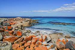
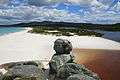
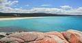
The Bay of Fires is a region of white beaches, blue water and orange-hued granite (the colour of which is actually produced by a lichen). The northern section of the bay is part of Mount William National Park; the southern end is a conservation area.[3]
A wide range of activities can be pursued in the Bay of Fires area, including camping, beach activities, boating, bird watching, fishing, swimming, surfing and walking.[4][5][6]
Pictures
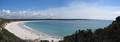
 Binalong Bay Beach
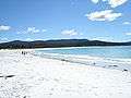
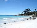 Beach and Rocks
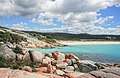
| Wikimedia Commons has media related to Bay of Fires. |
References
- Sprod, Dan (2005). "Furneaux, Tobias (1735 - 1781)". Australian Dictionary of Biography. Melbourne University Press. ISSN 1833-7538. Retrieved 5 May 2008 – via National Centre of Biography, Australian National University.
- Evans, Kathryn (1993). Shore-based whaling in Tasmania historical research project: Volume 2; site histories. Hobart: Parks & Wildlife Service. p. 66.
- Fitzgerald, Nick; Bay of Fires Coastal Preservation Lobby (Tas.); North-East Bioregional Network (Tas.) (2009), The Bay of Fires a new national park for Northeast Tasmania, North-East Bioregional Network, retrieved 10 January 2013
- "Bay of Fires". North East Tasmania. Archived from the original on 9 January 2008. Retrieved 13 January 2008.
- "Bay of Fires Conservation Area". Parks and Wildlife Service Tasmania. Archived from the original on 30 January 2009. Retrieved 13 January 2008.
- Richardson, Garry (2006), The Bay of Fires, St Helens and the Hinterland : a brief history and activities to enjoy, G. Richardson,c[2006], retrieved 10 January 2013
East Coast region of Tasmania, Australia | |||||
|---|---|---|---|---|---|
| Settlements | |||||
| Governance former | |||||
| Mountains | |||||
| Protected areas, parks and reserves | |||||
| Harbours, bays, inlets and estuaries | |||||
| Landmarks |
| ||||
| People of note | |||||
| Islands |
| ||||
| Books and newspapers | |||||
| Flora, fauna, and fishlife | |||||
| Bioregions | |||||
| |||||