Barra do Corda
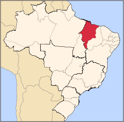
Barra do Corda (Portuguese pronunciation: [ˈbaʁɐ du kɔʁdɐ]) is a municipality in the state of Maranhão in the Northeast region of Brazil.[1][2][3][4]
Barra do Corda | |
|---|---|
Municipality | |
 Flag  Seal | |
| Nickname(s): Princesa do Sertão | |
 Barra do Corda Location in Brazil | |
| Coordinates: 5°30′S 45°15′W | |
| Country | Brazil |
| Region | Nordeste |
| State | Maranhão |
| Mesoregion | Centro Maranhense |
| Elevation | 486 ft (148 m) |
| Population (2016) | |
| • Total | 86,662 |
| Time zone | UTC -3 |
Climate
| Climate data for Barra do Corda | |||||||||||||
|---|---|---|---|---|---|---|---|---|---|---|---|---|---|
| Month | Jan | Feb | Mar | Apr | May | Jun | Jul | Aug | Sep | Oct | Nov | Dec | Year |
| Record high °C (°F) | 37.3 (99.1) |
36.1 (97.0) |
34.8 (94.6) |
34.6 (94.3) |
36.2 (97.2) |
36.3 (97.3) |
37.1 (98.8) |
39.8 (103.6) |
40.9 (105.6) |
40.0 (104.0) |
39.8 (103.6) |
40.4 (104.7) |
40.9 (105.6) |
| Average high °C (°F) | 31.3 (88.3) |
30.9 (87.6) |
30.9 (87.6) |
31.1 (88.0) |
31.5 (88.7) |
32.1 (89.8) |
33 (91) |
34.4 (93.9) |
35.3 (95.5) |
34.8 (94.6) |
33.8 (92.8) |
32.4 (90.3) |
32.6 (90.7) |
| Daily mean °C (°F) | 25.9 (78.6) |
25.6 (78.1) |
25.5 (77.9) |
25.8 (78.4) |
25.7 (78.3) |
25.5 (77.9) |
25.7 (78.3) |
26.9 (80.4) |
28.2 (82.8) |
28.5 (83.3) |
27.9 (82.2) |
26.9 (80.4) |
26.5 (79.7) |
| Average low °C (°F) | 22 (72) |
21.8 (71.2) |
22 (72) |
21.9 (71.4) |
21.3 (70.3) |
19.7 (67.5) |
18.9 (66.0) |
19.6 (67.3) |
21.9 (71.4) |
22.9 (73.2) |
22.9 (73.2) |
21.5 (70.7) |
21.5 (70.7) |
| Record low °C (°F) | 18 (64) |
18 (64) |
18.6 (65.5) |
18.2 (64.8) |
15 (59) |
12.6 (54.7) |
12 (54) |
10.2 (50.4) |
13.2 (55.8) |
14.4 (57.9) |
16.6 (61.9) |
18.2 (64.8) |
10.2 (50.4) |
| Average precipitation mm (inches) | 179.8 (7.08) |
199 (7.8) |
236.8 (9.32) |
187.5 (7.38) |
69 (2.7) |
16.2 (0.64) |
6.9 (0.27) |
12.3 (0.48) |
17.4 (0.69) |
37.8 (1.49) |
75.7 (2.98) |
138.7 (5.46) |
1,177.1 (46.29) |
| Average precipitation days (≥ 1.0) | 13 | 13 | 17 | 13 | 7 | 2 | 1 | 1 | 2 | 4 | 6 | 9 | 88 |
| Average relative humidity (%) | 83 | 85 | 87 | 87 | 83 | 74 | 67 | 61 | 60 | 64 | 70 | 77 | 75 |
| Mean monthly sunshine hours | 147.7 | 133.3 | 138.6 | 162.3 | 210.1 | 252.1 | 275 | 262.8 | 208.7 | 188.4 | 166.9 | 151.5 | 2,297.4 |
| Source: INMET[5] | |||||||||||||
Higher Education
- Logos Institute of Theology (Instituto Logos de Teologia)
gollark: I'm on my phone. Please reference lines nonnumerically.
gollark: (which might be your velocity, depending on how bad™ physics is)
gollark: You basically just base your launch power/direction on your offset from the height you want and the derivative of that offset.
gollark: Read the Wikipedia page. It's probably more helpful than me.
gollark: A PID controller without the I.
See also
References
- "Divisão Territorial do Brasil" (in Portuguese). Divisão Territorial do Brasil e Limites Territoriais, Instituto Brasileiro de Geografia e Estatística (IBGE). July 1, 2008. Retrieved December 17, 2009.
- "Estimativas da população para 1º de julho de 2009" (PDF) (in Portuguese). Estimativas de População, Instituto Brasileiro de Geografia e Estatística (IBGE). August 14, 2009. Retrieved December 17, 2009.
- "Ranking decrescente do IDH-M dos municípios do Brasil" (in Portuguese). Atlas do Desenvolvimento Humano, Programa das Nações Unidas para o Desenvolvimento (PNUD). 2000. Archived from the original on October 3, 2009. Retrieved December 17, 2009.
- "Produto Interno Bruto dos Municípios 2002–2005" (PDF) (in Portuguese). Instituto Brasileiro de Geografia e Estatística (IBGE). December 19, 2007. Archived from the original (PDF) on October 2, 2008. Retrieved December 17, 2009.
- "NORMAIS CLIMATOLOGICAS DO BRASIL 1961–1990" (in Portuguese). instituto nacional de meteorologia. Retrieved 19 May 2017.
This article is issued from Wikipedia. The text is licensed under Creative Commons - Attribution - Sharealike. Additional terms may apply for the media files.
