Ballintober North
Ballintober North (Irish: Baile an Tobair Thuaidh[1]), also called Ballintober East, is a barony in County Roscommon, Republic of Ireland.[2]
Ballintober North Baile an Tobair Thuaidh (Irish) | |
|---|---|
 Church in Whitehall, Ballintober North | |
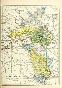 Barony map of County Roscommon, 1900; Ballintober North is coloured yellow, in the east. | |
| Sovereign state | Republic of Ireland |
| Province | Connacht |
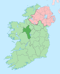
| County | Roscommon |
| Area | |
| • Total | 124.86 km2 (48.21 sq mi) |
Etymology
Ballintober North is named after Ballintober town; however, it does not actually contain that town, which is located in Castlereagh barony.
Geography
Ballintober North is located in the northeast of County Roscommon, bounded by the River Shannon to the east, an area with many lakes including Lough Boderg and Kilglass Lough.
History
This area was the ancient kingdom of Baghna, ruled by the Ó Fiannaigh (Feeney) tribe.[3] After them, the Hanleys (Ó hAinle) were the landlords of the area before losing their land in the mid-17th century.[4]
Its northern extreme was the plain of Caradh (modern Carranadoe), referred to in the topographical poem Tuilleadh feasa ar Éirinn óigh (Giolla na Naomh Ó hUidhrín, d. 1420).[5][6]
It was originally a single barony with Ballintober South; they were separated by 1841.
Wealthy landowning families in the 19th century were the Kings of Charlestown House, the Waldrons and the Goffs.[5][7]
List of settlements
Below is a list of settlements in Ballintober North:
References
- "Baile an Tobair Thuaidh/Ballintober North". Logainm.ie.
- "A map of Mullymucks in the barony of Ballintober South and County of Roscommon. Scale 40 perches to an inch. Names of tenants and acreage of holdings shown". catalogue.nli.ie.
- "The Baronies of Ireland - Family History". sites.rootsweb.com.
- "Estate Record: Hanly/Hanley". landedestates.nuigalway.ie.
- "The Topographical Poems of John O'Dubhagain and Giolla-na-naomh O'Huidhrin: Edited in the original Irish from MSS. in the Library of the Royal Irish Academy, Dublin, with translation, notes, and introductory dissertations, by John O'Donovan". A. Thom. 2 January 1862 – via Google Books.
- O'DONOVAN, JOHN (1843). THE TRIBES AND CUSTOMS OF HY-MANY, COMMONLY CALLED O'KELLY'S COUNTRY. p. 134 – via Internet Archive.
Ballintober East.
- "Ashfort House". landedestates.nuigalway.ie.
| .jpg) | |
| ||
Places in County Roscommon | ||
|---|---|---|
| Towns |
|  |
| Villages and Townlands |
| |
| ||