Baker Township, Morgan County, Indiana
Baker Township is one of fourteen townships in Morgan County, Indiana, United States. As of the 2010 census, its population was 717 and it contained 274 housing units.[1] The township contains Morgan–Monroe State Forest.
Baker Township | |
|---|---|
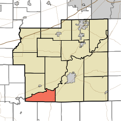 Location in Morgan County | |
| Coordinates: 39°21′22″N 86°32′51″W | |
| Country | |
| State | |
| County | Morgan |
| Government | |
| • Type | Indiana township |
| Area | |
| • Total | 15.66 sq mi (40.6 km2) |
| • Land | 15.41 sq mi (39.9 km2) |
| • Water | 0.24 sq mi (0.6 km2) 1.53% |
| Elevation | 702 ft (214 m) |
| Population (2010) | |
| • Total | 717 |
| • Density | 46.5/sq mi (18.0/km2) |
| Time zone | UTC-5 (Eastern (EST)) |
| • Summer (DST) | UTC-4 (EDT) |
| ZIP codes | 46151, 47433 |
| GNIS feature ID | 453094 |
Geography
According to the 2010 census, the township has a total area of 15.66 square miles (40.6 km2), of which 15.41 square miles (39.9 km2) (or 98.40%) is land and 0.24 square miles (0.62 km2) (or 1.53%) is water.[1]
Unincorporated towns
(This list is based on USGS data and may include former settlements.)
Cemeteries
The township contains Sodom Cemetery.
Major highways
School districts
- Metropolitan School District of Martinsville Schools
Political districts
- Indiana's 4th congressional district
- State House District 47
- State Senate District 37
gollark: Actually, JPEG XL good so that.
gollark: You mean "this is obviously the best possible standard format".
gollark: Idea: all Macron strings are PNGs of their text in a standard font.
gollark: .
gollark: I WILL prototype this
References
- "Baker Township, Morgan County, Indiana". Geographic Names Information System. United States Geological Survey. Retrieved 2009-09-26.
- United States Census Bureau 2008 TIGER/Line Shapefiles
- IndianaMap
- "Population, Housing Units, Area, and Density: 2010 - County -- County Subdivision and Place -- 2010 Census Summary File 1". United States Census. Archived from the original on 2020-02-12. Retrieved 2013-05-10.
External links
- Indiana Township Association
- United Township Association of Indiana
- City-Data.com page for Baker Township
Places adjacent to Baker Township, Morgan County, Indiana | |
|---|---|
Municipalities and communities of Morgan County, Indiana, United States | ||
|---|---|---|
| City | Map of Indiana highlighting Morgan County | |
| Towns | ||
| Townships | ||
| CDP | ||
| Other unincorporated communities |
| |
| Footnotes | ‡This populated place also has portions in an adjacent county or counties | |
This article is issued from Wikipedia. The text is licensed under Creative Commons - Attribution - Sharealike. Additional terms may apply for the media files.