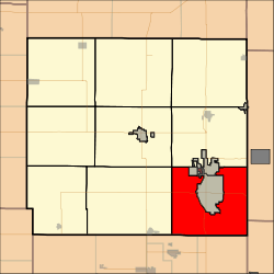
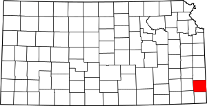
Baker Township, Crawford County, Kansas
Baker Township is a township in Crawford County, Kansas, United States. As of the 2010 census, its population was 3,408.[1]
Baker Township | |
|---|---|
 Location in Crawford County | |
| Coordinates: 37°24′24″N 094°40′28″W | |
| Country | United States |
| State | Kansas |
| County | Crawford |
| Area | |
| • Total | 56.83 sq mi (147.2 km2) |
| • Land | 56.8 sq mi (147.12 km2) |
| • Water | 0.03 sq mi (0.08 km2) 0.05% |
| Elevation | 919 ft (280 m) |
| Population (2010) | |
| • Total | 3,408 |
| • Density | 60/sq mi (23/km2) |
| GNIS feature ID | 0469616 |
Geography
Baker Township covers an area of 56.83 square miles (147.2 km2) surrounding the city of Pittsburg and a small part of the city of Frontenac. According to the USGS, it contains three cemeteries: Dietz, Frontenac and West Union.
The streams East Cow Creek, First Cow Creek and Second Cow Creek run through this township.
gollark: FREE prizekin!Just offer CB ND, Gold, 2 Silvers, 4 Coppers, good offers.
gollark: CB Gold.
gollark: Seriously, though, Terrafreaky has thousands! How do they have the patience?! Or time?
gollark: I've just bred all the ones I want to. Soon, my eggs shall be everywhere! All shall see the name of `osmarks`!
gollark: Well, probably not *all* of them.
References
This article is issued from Wikipedia. The text is licensed under Creative Commons - Attribution - Sharealike. Additional terms may apply for the media files.
